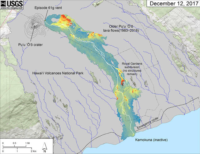
Lava erupting from the active vent on the east flank of Pu‘u ‘O‘o has not entered the ocean or reached the Kamokuna lava delta during the past month. Instead, small lava flows are scattered across the 61g flow field, breaking out from the lava-tube network between Pu‘u ‘O‘o and the coastal plain. Geologists of the Hawaiian Volcano Observatory last observed active lava atop the delta on November 17.
For nearly 16 months beginning on July 26, 2016, lava traveled through an evolving lava-tube network into the ocean at Kamokuna. Lava alternately (1) built new land into the ocean when the steep submarine slope grew sufficiently seaward to support a lava delta; and (2) poured directly into the ocean as a great lava fall when the delta and submarine slope collapsed, shearing the tube at the sea cliff and exposing a lava stream 3 to 6 feet in diameter gushing into the ocean.
Earlier this year, with commercial boat operators taking people to the lava entry by sea, thousands of people viewing the lava fall from the established viewing area inside Hawaii Volcanoes National Park or by helicopter, more people probably witnessed this lava fall than any other since lava first reached the ocean in 1986.
Why did the lava delta become inactive? Simply, lava stopped reaching the delta either through the tube or as surface flows, slowly at first, and then intermittently.
Most likely, a combination of three factors prevented lava from reaching the delta.
First, many scattered breakouts from the lava-tube network between Pu‘u ‘O‘o and the delta effectively decreased the amount of lava reaching the coast. A series of breakouts from the upper section of tube this past summer developed into a second tube on the east side of the 61g flow, diverting an increasing volume of lava from the primary (west) tube and ultimately, the delta.
For at least the past few weeks, this east tube, which has not yet reached the ocean, appears to be supplying more lava to surface flows than the west tube.
Second, starting in mid-November, tiltmeters at the summit of Kilauea recorded two sharp deflationary trends followed by alternating deflation-inflation episodes. These tilt patterns have corresponded well during the Pu‘u ‘O‘o eruption to a decrease in the supply of magma or an interruption in supply of magma to the erupting vent, respectively.
Less lava erupting from the vent results in less lava entering the tube network, further diminishing the volume reaching the coastal plain in either branch of the tube network.
Finally, by mid-November one or more restrictions along the west lava tube on the coastal plain blocked the entire underground lava stream from reaching the delta. Several breakouts from the tube within 300 feet of the sea cliff had flowed onto the delta or into the ocean in recent months but after Nov. 14, these flows were too small to make it that far. No active flows in this area have occurred since Nov. 22.
If the east tube continues to capture more of the lava stream from the west tube and more voluminous breakouts spread eastward, they could eventually travel towards the coast along steepest-descent paths east of the current 61g flow. Stay tuned to the flow’s next move by visiting the HVO website for updated thermal maps, updates, and photographs of the flow field.
Volcano Activity Updates
This past week, Kilauea Volcano’s summit lava lake level fluctuated with summit inflation and deflation and ranged about 30-44 m (98–144 ft) below the vent rim. On the East Rift Zone, the 61g flow remained active, with scattered breakouts downslope of Pu‘u ‘O‘o, but not at the ocean entry. The 61g flows do not pose an immediate threat to nearby communities.
Mauna Loa is not erupting. During the past week, small-magnitude earthquakes continued to occur beneath the volcano. Shallow seismicity was concentrated beneath the summit caldera and upper Southwest Rift Zone at depths less than 5 km (3 miles). Additional deeper seismicity (5-20 km or 3-12 miles) was scattered beneath the southeast flank of the volcano. Global Positioning System (GPS) and Interferometric Synthetic Aperture Radar (InSAR) measurements continue to show deformation related to inflation of a magma reservoir beneath the summit and upper Southwest Rift Zone. No significant changes in volcanic gas emissions were measured. Overall rates of deformation and seismicity have decreased towards long-term background levels. Similar decreases have occurred in the past during the ongoing period of unrest that started in 2014; it is unknown if these low rates will persist or if they will pick up again in the near future.
No earthquakes were reported felt in the Hawaiian islands during the past week.