HILO — Kilauea volcano erupted new fissures Friday inside Leilani Estates and produced the largest earthquake in Hawaii since 1975, causing residents around the island to take cover.
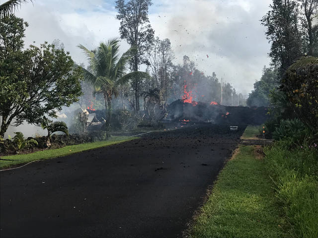
Six fissures had opened by late Friday, with one sending lava onto Pohoiki Road, making it impassable. Two homes have been confirmed destroyed and hundreds of residents have been displaced.
The magnitude-6.9 quake occurred at 12:32 p.m. on the volcano’s south flank and was one of several large temblors Friday that shook buildings and rattled nerves.
Some businesses and schools closed for the day, and 14,000 Hawaii Electric Light Co. customers lost power for a few hours in East Hawaii. Landslides also were reported along the Hamakua Coast.
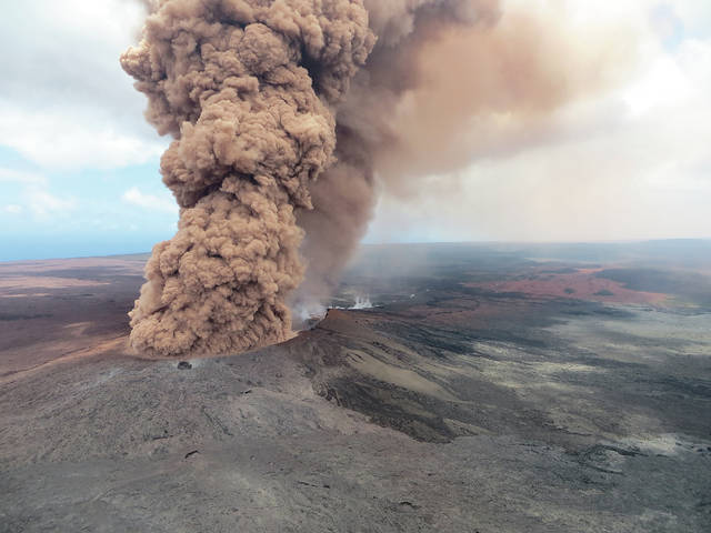
Hawaii Volcanoes National Park closed because of damage from the quake. About 2,600 visitors were evacuated.
The eruption started Thursday inside Leilani Estates on Kilauea’s lower East Rift Zone. It followed several days of heightened seismic activity and the collapse of Pu‘u ‘O‘o’s cone on Monday. Another ash plume was seen over the cone following the strong quakes Friday.
In Leilani, fissures have been erupting one after another, but not all have been active at the same time. Lava flows have so far remained near the vents, but geologists warn that can quickly change.
Each vent is located around the lower end of the subdivision, which is under a mandatory evacuation since Thursday.
Janet Snyder, spokeswoman for the Mayor’s Office, said the sixth fissure opened at or near the intersection of Leilani Avenue and Pohoiki Road.
A command post at that intersection was relocated to the Pahoa Fire Station.
That intersection is near Lanipuna Gardens, which also is under a mandatory evacuation order. Snyder said the county was trying to get the remaining residents in Lanipuna to leave. Shelters are open at the Pahoa and Keaau community centers.
In response, the county closed Highway 132 from Highway 137 to Kaululaau Road, police said.
The county also issued an emergency water restriction for most of lower Puna. A county water line runs under Pohoiki Road.
That area is near the Puna Geothermal Venture power plant, which has been closed and secured, according to the county.
Highway 130 also is closed past Leilani due to hazardous gas emissions from the vents.
The U.S. Census Bureau estimates about 1,600 people live in Leilani.
Gas emissions remain hazardous in Leilani. However, county staff said not everyone has left.
No injuries had been reported by Friday evening, though Civil Defense Administrator Talmadge Magno said one person may have suffered cardiac arrest as a result of the event.
While county staff say there is a strict no-entry policy, Mayor Harry Kim said the county will try to accommodate people who want to return to their homes if it becomes safe.
“All of us have got to remember this is a tragedy on them, and we have to work with them on how to minimize it as best as possible,” he said.
Nine quakes of magnitude 4 or higher occurred near Kilauea’s East Rift Zone by Friday evening. Three were at least magnitude 5.
Michael Dewey, Suisan Fish Market manager, said the Hilo retail market closed for the day due to tsunami fears. He estimated the water level there receded 4 to 5 feet.
“Watching the water recede was concerning, and the decision was made by our safety manager to evacuate the market,” he said. “The 6.9 was pretty intense.”
A voluntary evacuation occurred at Valhalla and Riverside apartments in Hilo after the quakes, Snyder said.
No tsunami was generated, though Civil Defense said small sea level changes were detected of 20 centimeters in Hilo, 40 centimeters in Kapoho and 15 centimeters in Honuapo.
The 6.9 quake occurred around the same location as a magnitude-7.2 temblor in 1975 that created a tsunami and killed two people.
Janet Babb, Hawaiian Volcano Observatory spokeswoman, said the quake was produced as a result of magma causing stress on the flank. Additional strong aftershocks are possible.
Babb said HVO geologists are taking samples of the lava in Leilani that could tell them more about this eruption.
“The bottom line is the eruption is very dynamic,” she said. “There still can be changes. This is not over.”
Email Tom Callis at tcallis@hawaiitribune-herald.com.


How about starting a rescue fund to help the people who have been evacuated, and especially those
who have already lost their homes ? They need our help urgently and NOW. The fund could be called “PELE’S RESCUE FUND” or something like this. It could be organized by the County of Hawaii.
I would prefer to give to such a group rather than to the Red Cross or religious groups.
Those of us who are lucky to be safe from lava flows, the majority, should be happy to make a fair
donation and in no time the new fund could collect and distribute a substantial amount of money
to the affected people that are badly in need of quick and generous help. I pledge $100.
You lost me when you suggested the county of Hawaii be put in charge of such a fund. Not sure what your beef is with Red Cross or religious groups are, but that’s the groups that can help the best. You not aware how slow Government works on anything that is helpful to the public? The government is doing there job as it should be at this time, but later it will be a slow go.
The Red Cross is still holding hundred’s of millions of dollars it collected following 9/11 and the Great Japanese Earthquake of 2011. It never dispersed all the funds to victims. They claim they have right to hold money in reserves for future events. Meanwhile the head of the Red Cross draws a $600,000 annual salary.
I would never donate to any organized charity again. They have lost my trust. I give money directly to the people who need it.
Ige to Kim…..how can we make money from this lava flow thing.
Hate to say this but Harry Kim will impose a West Hawaii only tax to take care of the Lava flow displacement…or…he will redirect general funds from West Hawaii to East.
Aloha. Can someone please ask USGS why there is a large spike event on deformation Mauna Loa last night around 2400? Cause I see neighbors here in Cpt Cook packing up and engines running. What is happening? My hubby is at work but I’m wondering what that big spike is? Go go USGS Mauna Loa, click on Monitoring, then Deformation. Scroll a bit down to see the graph with the spike and do an article so we are not in the dark here. Mahalo!
You mean the graph showing “Electronic Tilt at Mauna Loa Summit”? Time of the spike I see actually looks like around mid-day on 5/4… so guessing it just picked up the earthquake. No?
Yes, the tiltmeter spike on Mauna Loa Summit. Is the time midday and not midnight? If it is, thank you for clarifying. Looked to me like it happened between both those days at night though. Mahalo.
I think so. Wasn’t aware of that site — interesting, mahalo for sharing that .
So, the bigger question here is, whose brilliant idea was it to allow a housing subdivision to be built less than a half mile from the “lava flow of 1955”, as it’s described on the Google map. They had to know they were rolling the dice, the Pahoa event a few years back is just a little bit north. This is ground zero, and there are houses? That’s nuts. You have to feel bad for the people living there, but if you build a house on the tracks and a train hits you . . . whose fault is that?