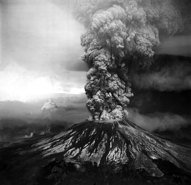
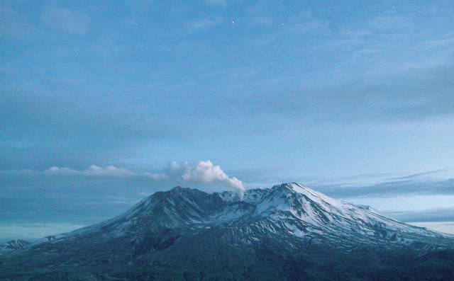
HILO — The explosion early Thursday morning of Halema‘uma‘u crater, which sent a volcanic ash cloud 30,000 feet high and deposited a light layer of ash on Hawaii Volcanoes National Park and surrounding areas, reminded two displaced Leilani Estates residents of an event that took place 38 years ago Friday — the violent explosion of Mount St. Helens, which killed 57 people directly and caused more than $1 billion in damage.
“It was May 18, 1980. That date has stuck with me more than anybody’s birthday,” said Tina Floyd, who’s staying in the Keaau emergency shelter with her cat, Popua. “It was a Sunday morning. I was in the shower when she blew. I walked outside and went, ‘What is all over everything. It kind of looked like snow, just white dust. These guys here are talking about ashfall and get kind of worked up about it. But you haven’t seen ashfall until half a mountain totally blows its lid.
“It had been going off for months before that, steam plumes and little eruptions and earthquakes. And then it was gone with the ash.”
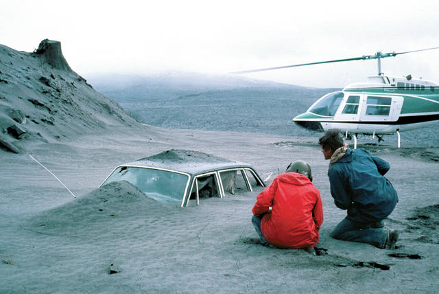
The eruptive column rose 80,000 feet into the air and deposited ash in 11 U.S. states.
“I have ash from that original day,” said Janet Morrow, who’s staying at the Pahoa emergency shelter. “We were halfway over to Yakima, which really got dumped on.”
Yakima, by the way, is 85 miles away from the mountain as the crow flies, but ash from Mount St. Helens left a thick layer of ash in Spokane, in eastern Washington, almost 250 miles away.
“I know people who couldn’t even find where their property once was because the mudslides just totally made everything unidentifiable,” Morrow said.
Floyd was in Olympia, the state capital, 67 miles from the volcano.
“When you’d drive south on (Interstate 5), you’ve got these mountains of ash as tall as this building. Just bare, gray ash, like berms,” she said. “For years, it was just kind of gray. Then, things started growing out of it and now, you can’t tell it was ash there.”
Among those killed by the explosive eruption was Harry R. Truman, the 83-year-old owner of Mt. St. Helens Lodge at Spirit Lake, located at the base of the mountain. As earthquakes occurred frequently in the months preceding the eruption and residents were ordered to evacuate, Truman stayed put, gaining folk hero status.
“I was telling the story of Harry Truman this morning,” Floyd said. “He would not leave. They tried to coax him out, lure him out, and he was, like, ‘I’ve lived here all my life. I’m not leaving. I’m going to go when the mountain goes.’ And he did.”
And the legend goes, according to Floyd, that Spirit Lake, which was a popular tourist destination before the eruption, is now imbued with Truman’s spirit.” An HBO docudrama, “St. Helens,” followed, with Art Carney of “The Honeymooners” fame portraying Truman.
The date May 18 has stuck with Floyd more than anyone’s birthday — but for Morrow, it was her birthday.
“Unfortunately, Mount St. Helens went off on my birthday and I was in that area. I got kidded for years. ‘Tone down the birthday parties,’” Morrow said.
“And grrrrrr, I didn’t need this event right now.”
Email John Burnett at jburnett@hawaiitribune-herald.com.