HILO — As the lower Puna eruption continues, the county is evaluating ways to safely reopen roads in the area and even allow people to view the lava.
Hawaii County spokeswoman Janet Snyder quoted Mayor Harry Kim on Tuesday as saying that the county is under some pressure from residents to reopen closed roads in lower Puna, such as parts of highways 132 and 137, which have been cut off by the lava flow.
Kim said reopening the roads will cost “tens of millions of dollars,” Snyder said.
“There will be no attempt to clear or fix the government roads until there is a minimum of six months of (lava) inactivity,” Snyder said.
County Managing Director Wil Okabe said only a handful of people are requesting that closed roads be opened. Significantly more, however, are requesting that the county set up a lava viewing area near the evacuation zone.
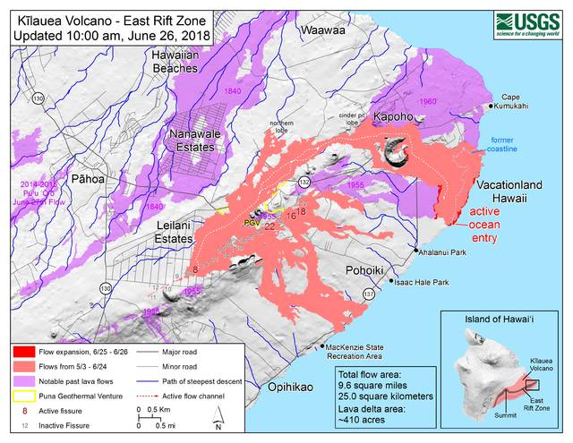
One commonly discussed site for such a viewing area could be at the intersection of Pohoiki Road and Highway 132, which features a direct line of sight to the still-active fissure 8, as well as recently installed warning signs along the edge of the flow.
Okabe could not confirm where a potential viewing site could be located, but confirmed that the county is evaluating several locations around the affected area.
Until the county can determine a number of factors — for example, Okabe said, traffic control, air-quality monitoring, security — no legal viewing area will be established anywhere.
“We don’t want a situation like that guy who died in Kalapana,” Okabe said, referring to Sean King, a tour guide who died in February after being exposed to laze caused by rain falling on the lava flow.
Still, Snyder said, Kim is excited about the possibilities of such an attraction.
“Can you imagine the business that would come to Pahoa if we open it as a triage area and let people in, in groups,” Snyder quoted Kim as saying.
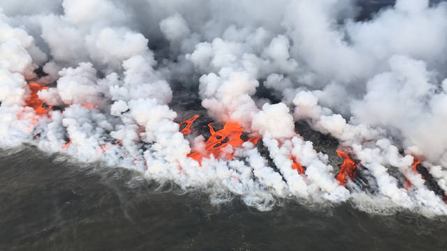
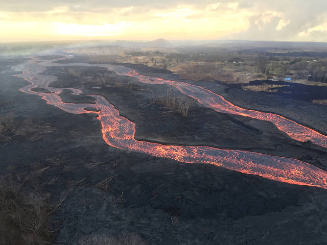
There appears to be little risk of the lava stopping before such a viewing area is built, with fissure 8’s activity still as strong as ever. Fissures 15 and 18 were incandescent Tuesday, but not flowing, while fissure 22 generated a weak flow with spattering.
The flow’s ocean entry caused a significant amount of laze Tuesday, with a line of rivers more than half a mile long oozing into the water.
Not far from the southern ocean entry, four people were cited Monday afternoon for loitering in the mandatory evacuation zone at the MacKenzie State Recreation Area. The four — 30-year-old Mitchell Shroyer of Wisconsin and Christopher McWherter, 36, Nicholas Allen, 27, and Joshua Allen, 32, all of California — each were cited with trespassing and loitering in a disaster area.
The state Department of Land and Natural Resources reported Tuesday that police and the department’s Division of Conservation and Resources Enforcement have issued more than 80 such citations since the eruption began in early May.
In other developments:
• Snyder said Kim met with representatives of Ormat Technologies Inc., which manages Puna Geothermal Venture, regarding the company donating an undetermined amount of money to the county.
• The Food Basket, Hawaii Island’s food bank, and the Hilo Farmers Market will cooperate with the Sioux Honey Association Co-op — a nationwide collective of beekeepers — to host a produce drive to benefit lava evacuees. On Wednesday and Saturday, residents can donate fresh produce as well as money at a booth at the Hilo Farmers Market.
• Today marks the fourth anniversary of the beginning of the 2014 Puna lava flow.
Email Michael Brestovansky at mbrestovansky@hawaiitribune-herald.com.
Email John Burnett at jburnett@hawaiitribune-herald.com.


Yeah, I was just thinking that some private land owners along the river of lava might benefit from charging admission to some kind of raised platform where you could watch. Lots of safety issues involved of course, although the “banks” appear to be stable, any sudden crack and eruption of lava could overwhelm a viewing area that was too close. Probably not a goer.
Harry Kim pressured to open roads? Don’t buy that for a second, there’s a personal gain by any decision he makes and this on the eve of the reconsideration of the GET tax? What a load of cr*%p, don’t believe a word this lunatic carefully crafts through his many mouthpieces he has in place.