Major mixed-use plan marches forward
KAILUA-KONA — A development carrying about 300 residences and more than 200 hotel rooms passed a major milestone earlier this month when the county’s Planning Department determined the $65 million project won’t have significant environmental impacts on the area.
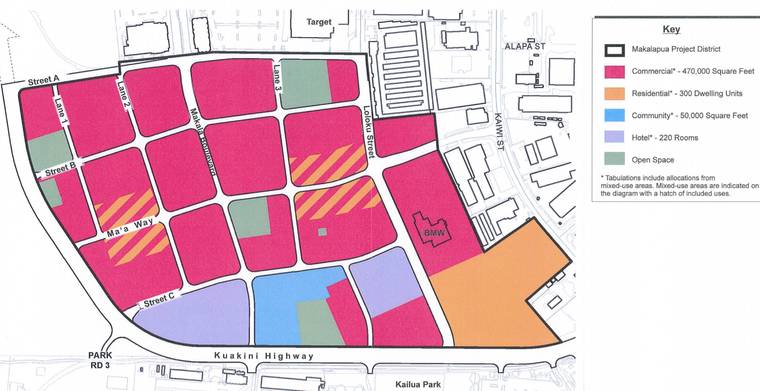
The final environmental assessment for the Liliuokalani Trust’s Makalapua Project District also outlines a new road network for the planned mixed-use development, which its advocates expect will offer residents a new space in which to work, live, shop and play.
“It’s like everything’s right there. You don’t necessarily need to have a car if that’s the type of livable space you can look for,” said Kirstin Kahaloa, a member of the community advisory group of Liliuokalani Trust, which owns the more-than-67 acres that make up the project site. “And of course the opportunity to add more housing, especially a different type of housing that we’re not necessarily used to seeing in West Hawaii, I think that’s very exciting.”
There are still some approvals needed on the county level, and Michael Shibata, director of real estate at the Liliuokalani Trust said they anticipate starting to break ground in 2021. The project will be developed over 15 years with a “significant portion” expected to be completed within the first 10.
The Liliuokalani Trust owns about 6,200 acres throughout Hawaii, the vast majority of which is on Hawaii Island. Its properties include the Kona Industrial Park (just east of the project area) and the fee interest in five shopping centers, such as Kona Commons, which is just mauka of the project site.
Unlike those other properties, the Makalapua Project District is a new approach for the trust, said Shibata.
“People love to see retail on the ground floor with residential above,” he said. “You don’t really see it too often, but it’s successful in various places.”
A key aim identified in project documents is to meet the area’s rising housing need while also offering commercial and recreational opportunities.
Census estimates put Hawaii County at the top for population growth in the state, with growth expected to continue. The project’s environmental assessment cited state data anticipating the island’s population to grow by 59.8 percent between 2010 and 2040, compared to 25.3 statewide.
The Makalapua Project District will include about 300 residential units, along with 220 rooms across two hotels in addition to commercial and recreational space.
Kahaloa said she believes the project is one that is “definitely for the community and for residents.”
“And it’s going to serve visitors as well, but that is, to me, not the point,” she said. “It’s about having opportunities, again, for safe, fun places for our community — families, parents, keiki — to come together really to live, work and play.”
Shibata said the aesthetics are still being worked out, but they want to keep it authentic with the region.
“So I think a part of it is being respectful to culture, place, and obviously the desire is we want to do a great job in doing it and getting it right,” he said. “So, I think that will be very key in terms of establishing proper place-making and creating that look and feel that reads that this project is from here.”
The project also emphasizes its walkability, with Makala Boulevard envisioned as a “walkable main street with on-street parking, serving as the focus for pedestrian-oriented retail, social activity and public strolling within the project district.”
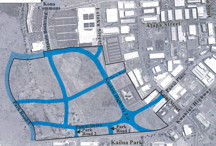
The road network plans outlined in these latest documents are substantially different than what was included in the draft environmental assessment published in March 2017. While the original plan extended Pawai Place east through the project area, that plan was replaced in the final document with a plan to run Kuakini Highway east along its current alignment before bending mauka around the project area.
The final plan also adds two more east-west streets on either side of an extended Maa Way as well as additional mauka-makai roadways in the project area.
There are still some approvals needed before the project can move forward, including petitioning for a boundary amendment to redesignate a little less than 15 acres in the state’s agricultural district to urban, like the rest of the site. Because it involves less than 15 acres, that can be processed at the county level with final approval up to the County Council.
Councilmembers would also have to OK a county zoning change for the area, which is currently considered general industrial, industrial-commercial mixed and agricultural. Liliuokalani Trust plans to request the zoning be changed to project district, which would allow for a “flexible, creative, planning approach instead of specific land use designations.”
The project will also require the filing of a planned unit development application and special management area use permit, both of which would need the approval of the county’s Leeward Planning Commission.
Shibata said they plan to pursue all of those approvals on the same timeline and they’re hoping to submit their applications in the third quarter of this year.
