The 2018 Lower East Rift Zone eruption and summit caldera collapse marked the end of the 35-year-long Puu Oo and 10-year-long summit lava lake eruptions, and the beginning of a new chapter in Kilauea Volcano activity. The volcano is continuing to behave in ways that are a response to the major events of 2018 and “the new normal” is yet to be defined.
The range of possibilities for future events at Kilauea is wide open and any new post-eruption observation sparks investigation as we work to better understand the volcano’s current and future state.
One such observation was the first post-eruption detection of a summit Deflation-Inflation event (DI-event) in late 2018. The return of DI-events was a clue that the shallow Halemaumau reservoir — a magma chamber about 1 mile under Kilauea caldera — still contained significant amounts of magma. Another important post-eruption “first” was the formation of a water lake within Halemaumau, which hasn’t occurred for at least 200 years and could have serious implications for volcanic risk.
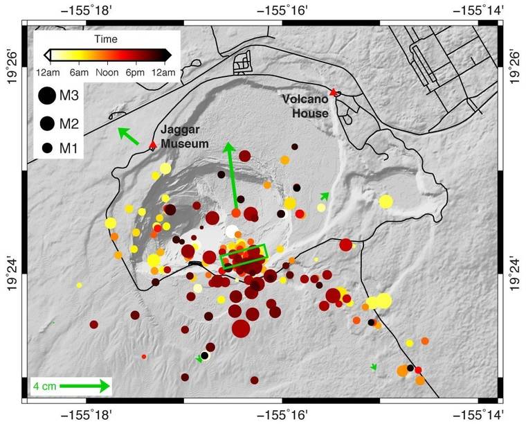
Recently, the USGS Hawaiian Volcano Observatory’s (HVO) monitoring network recorded another first post-eruption event at Kilauea’s summit: a magmatic intrusion. Following an earthquake swarm on Nov. 30, 2020, that was centered in the middle of Kilauea caldera, several pulses of heightened earthquake activity were recorded in the upper East Rift Zone. During the early morning hours of Dec. 2, HVO detected another spike in summit seismicity rates, which continued throughout the day. Then, at about 5:45 p.m., earthquake activity intensified, this time centered under the southern part of Kilauea caldera, near the edge of the new down-dropped eastern portion. At the same time, tiltmeters began to record accelerated deformation in directions that differed from typical patterns.
Both the swarms and pattern of ground deformation were consistent with a small dike intrusion under the southern part of Kilauea caldera. A dike intrusion is an injection of magma into host rock and can sometimes precede an eruption. But often, like on Dec. 2, the injection does not reach the surface.
Intrusions have been recorded at Kilauea’s summit many times. A notable recent occurrence was in May 2015, when inflation of Kilauea’s shallow Halemaumau reservoir led to a week of overflows of the summit lava lake and sprays of spatter visible from the Jaggar Museum overlook. That ended when magma was diverted to an intrusion in Kilauea’s south caldera region, which lowered the summit lava lake.
Preliminary models suggest that the Dec. 2 intrusion was small. It contained anywhere from 10 to 30 times less magma than the intrusion in May 2015 and its volume is equivalent to the amount of lava erupted in just one to two hours from Fissure 8 during the 2018 eruption. However, even though it’s small, it’s still a potential clue for future behavior.
In 1974, earthquake swarms in the upper East Rift Zone and southern portion of Kilauea caldera, as well as changes in summit tilt, preceded an eruption from Keanakakoi Crater by about 10 hours. The 1974 eruption produced lava fountains up to 100 feet high and sent lava flowing into Kilauea caldera. The eruption also opened fissures near Luamanu Crater that sent a lava flow over Chain of Craters Road.
This scenario was in the minds of HVO scientists as the events of Dec. 2 unfolded and an overnight watch was established to closely monitor data feeds. However, as the HVO Information Statement on Dec. 3 indicated, earthquake rates and deformation slowed down quickly, and no additional signs occurred to indicate that an eruption was truly imminent. Seismicity and deformation rates under Kilauea’s summit have mostly returned to what they were prior to this intrusive episode, although a new swarm of very small earthquakes is being monitored as this article goes to press.
Though small, this intrusion is a reminder that Kilauea can still be considered one of the most active volcanoes on earth and that the next eruption from Kilauea Volcano is just a matter of time. We are still encountering new “firsts” in the post-2018 regime that lead us toward a better understanding of this new period of activity. HVO, as always, keeps a close eye on monitoring data for any changes, big or small.
Volcano Activity Updates
Kilauea Volcano is not erupting. Its USGS Volcano Alert level remains at NORMAL (https://www.usgs.gov/natural-hazards/volcano-hazards/about-alert-levels). Kilauea updates are issued monthly.
Kilauea monitoring data for the past month show variable rates of seismicity and ground deformation, low rates of sulfur dioxide emissions, and only minor geologic changes since the end of eruptive activity in September 2018. A Kilauea Information Statement on Dec. 3 summarized increased seismicity beneath the summit during Nov. 29 through Dec. 3. Ground deformation rates accompanying the seismicity had a brief excursion from recent trends; other monitoring data streams remained stable. Increased seismicity has diminished but continues; ground deformation rates have stabilized; other monitoring data streams remain stable and show no signs of increased activity. The water lake at the bottom of Halema’uma’u continues to slowly expand and deepen. For the most current information on the lake, see https://www.usgs.gov/volcanoes/Kilauea/k-lauea-summit-water-resources.
Mauna Loa is not erupting and remains at Volcano Alert Level ADVISORY. This alert level does not mean that an eruption is imminent or that progression to eruption from current level of unrest is certain. Mauna Loa updates are issued weekly.
This past week, about 113 small-magnitude earthquakes were recorded beneath the upper-elevations of Mauna Loa; most of these occurred at shallow depths of less than 5 miles. Slightly increased earthquake activity continues on Mauna Loa’s northwest flank, which began on Dec. 4. In the past week, HVO has recorded 98 earthquakes in this region. Earthquake swarms in this region have occurred previously in October 2018, April 2017, July 2016, August 2015 and earlier, and do not indicate that an eruption is imminent. GPS measurements show long-term slowly increasing summit inflation, consistent with magma supply to the volcano’s shallow storage system. Gas concentrations and fumarole temperatures as measured at both Sulphur Cone and the summit remain stable. Webcams show no changes to the landscape. For more information on current monitoring of Mauna Loa Volcano, see: https://www.usgs.gov/volcanoes/mauna-loa/monitoring.
There were threee events with three or more felt reports in the Hawaiian Islands during the past week: a magnitude-1.7 earthquake 6 miles east of Pahala on Dec.14 at 7:38 p.m., a magnitude-2.2 earthquake 11 miles south-southeast of Waimea on Dec. 14 at 10:40 a.m., and a magnitude-4.4 earthquake 12 miles south-southeast of Waimea on Dec. 14 at 9:27 a.m.
Visit https://www.usgs.gov/observatories/hawaiian-volcano-observatory for past Volcano Watch articles, Kilauea and Mauna Loa updates, volcano photos, maps, recent earthquake info, and more. Email questions to askHVO@usgs.gov.
Volcano Watch is a weekly article and activity update written by U.S. Geological Survey Hawaiian Volcano Observatory scientists and affiliates.