It has been an exciting week at Kilauea Volcano as the summit eruption that began on the evening of December 20th continues. The eruption remains confined within Halema‘uma‘u crater. Monitoring data show no signs of activity migrating from the summit into the rift zones, nor indications of summit collapse like those in 2018.
The primary hazard from this eruption at this time is vog (volcanic air pollution) produced by the gases emitted at the summit. USGS Hawaiian Volcano Observatory (HVO) scientists continue to closely monitor the eruption.
As last week’s “Volcano Watch” went to press, lava continued to erupt from two vents on the west and north sides of Halema‘uma‘u crater at a combined rate of approximately 30 cubic meters per second. The rise of the lava lake was slowing due to the funnel-like shape of Halema‘uma‘u.
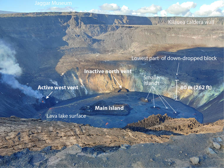
By Christmas night, the lava lake had risen slightly above the level of the north vent, which to this point was the dominant source of lava for the eruption. Lava fountaining from the north vent, which built an amphitheater-shaped cone surrounding it, drove circulation in the lava lake apparent in the motion of the crust.
Early in the morning on Dec. 26, the biggest change in eruptive activity was observed. At approximately 3 a.m. HST, activity at the west vent increased dramatically as the fountaining at the north vent died out. HVO scientists observing the lake witnessed lava draining back into the north vent and the lake level dropped 5 meters over the next few hours. This left a ‘bathtub ring’ around the edge of the lake, marking the lake’s high point. The change in active vent also saw a decrease in sulfur dioxide (SO2) gas output, down from 16,000–20,000 tonnes per day on December 25th to 3,800 tons per day on Dec. 30.
The lava lake level has been rising slowly again since December 27th and, as of writing this article, it has reached a new peak elevation of 701 m above sea level (asl) and depth of 184 m. The erupted volume to this point is more than 20 million cubic meters or about 8,000 Olympic-sized swimming pools! The eruption rate has decreased to approximately 10 cubic m per second. On Dec. 30, the lake measured 800 m east-west and 530 m north-south, covering an area of 82 acres. Lava continues to erupt from the west vent.
One of the most common questions that HVO gets is, “When will the lake be visible from an open area of Hawai‘i Volcanoes National Park?” and “Will the lava lake fill Halema‘uma‘u?” These questions are difficult to answer because the activity within Halema‘uma‘u is dynamic. After the eruption first started, the lava lake rose rapidly both due to the shape of the base of Halema‘uma‘u (inverted cone) and the initially high rates of lava being erupted.
Since then, the rate of lava being erupted has varied, especially as activity shifted from the north to the west vent, with associated lava drainback into the inactive north vent and a temporary decrease in lake level. However, HVO has done some preliminary calculations to try and answer these questions using topographic models and the most recent eruption rate.
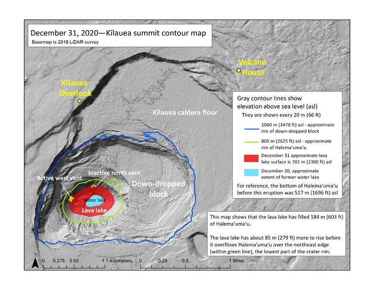
The lava lake should be visible from Kilauea Overlook once it reaches an elevation just over 780 m asl, then another 5 m of rise will have it overflowing the lowermost rim of Halema‘uma‘u on the northeast side. Since the lava lake is currently at about 701 m asl, it has about 80 m to rise before it reaches the level of visibility. When it does so depends on the rate of lava being erupted.
Assuming a constant eruption rate of 10 cubic meters per second, it would take approximately 45 days for lava to fill Halema‘uma‘u to just over 780 m asl, therefore becoming visible from Kilauea Overlook. Several days later it would start overflowing the lowermost rim of Halema‘uma‘u at just below 800 m asl. However, it would likely take longer as the eruption rate has been fluctuating and generally decreasing. If lava did overflow Halema’uma’u, it would then need to fill the extensive down-dropped block area before overflowing onto the main caldera floor.
HVO continues to closely monitor this eruption in Halema‘uma‘u at Kilauea’s summit. Check the HVO website for photo, video, and text updates: www.usgs.gov/hvo. Please visit HVO’s website for past Volcano Watch articles, Kilauea and Mauna Loa updates, volcano photos, maps, recent earthquake info, and more. Email questions to askHVO@usgs.gov.
Volcano Watch is a weekly article and activity update written by U.S. Geological Survey Hawaiian Volcano Observatory scientists and affiliates.