Volcano Watch: Learning from the 1984 eruption of Mauna Loa
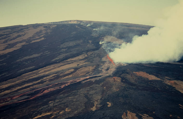
An erupting fissure on Mauna Loa's Northeast Rift Zone is seen March 25, 1984. (USGS/Special to West Hawaii Today)
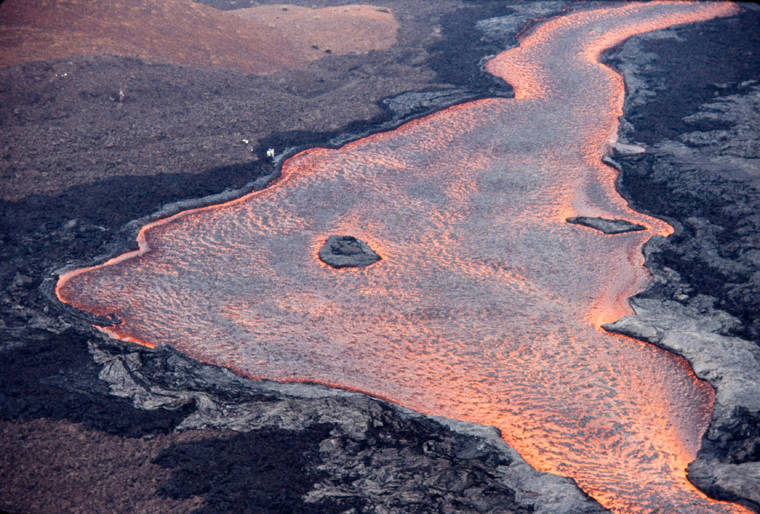
Mauna Loa tends to erupt large, fast-moving lava flows. Here, lava flowed downstream (toward bottom-right of photo) through this a‘a channel down rift from the main vent. For scale, note the USGS scientists at work on the left side of the 77-yard-wide lava channel. (USGS/Special to West Hawaii Today)
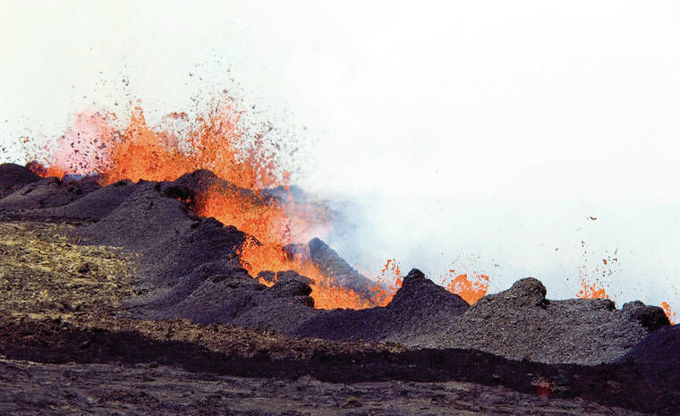
A fissure erupts near the 11,155-foot elevation of Mauna Loa’s northeast rift zone, feeding aa lava flows toward Kilaue in 1984. (USGS/Special to West Hawaii Today)
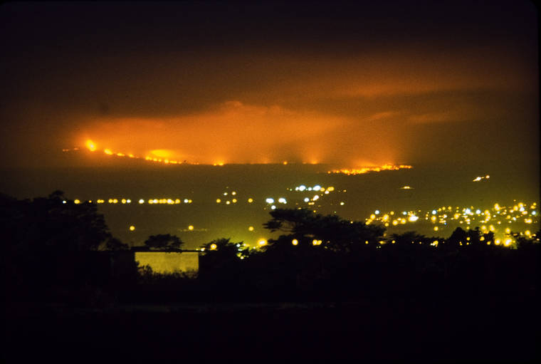
Glow from a Mauna Loa lava flow lights up the night sky above Hilo on April 4, 1984. In this photo, captured from near the Hilo airport, the flow front appears closer to the city than it actually was. (David Little/Special to West Hawaii Today)
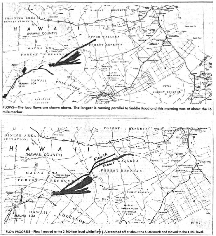
Maps showing lava flow progression during the 1984 eruption of Mauna Loa. These maps were featured in the Hawaii Tribune-Herald newspaper on March 27, 1984 (top) and March 30, 1984 (bottom). (Courtesy photos/Special to West Hawaii Today)
Inflation and earthquake activity ramped up prior to Mauna Loa’s 1984 eruption, so much so that in June of 1983, the USGS Hawaiian Volcano Observatory (HVO) indicated that an eruption could occur during the following year, though the exact timing was unknown.
Inflation and earthquake activity ramped up prior to Mauna Loa’s 1984 eruption, so much so that in June of 1983, the USGS Hawaiian Volcano Observatory (HVO) indicated that an eruption could occur during the following year, though the exact timing was unknown.
Increased earthquakes and tremor, a type of seismic signal associated with magma movement, began mere hours before glow was observed at the summit of Mauna Loa at 1:25 a.m. on March 25, 1984. A few hours later, the eruption migrated to vents lower on the Northeast Rift Zone of the volcano. Vent locations and lava flow directions weren’t known until HVO was able to conduct an overflight at dawn.
For the next three weeks, multiple lava flows slowly advanced in a northeast direction toward Hilo town. Much of the state was impacted by vog — volcanic air pollution.
HVO monitored Mauna Loa’s 1984 eruption from the ground and air, but adverse weather would sometimes prevent visual observations, and therefore eruption updates. Heat released during the eruption caused convective currents resulting in local thunderstorms and snowfall in the vent region.
Though lava flows did not cross it, the Saddle Road (Highway 200) remained closed during the 1984 eruption. Eruption spectators caused traffic congestion in Hilo, and some risked their safety to trespass into the closed area.
Some power poles and lines were destroyed by a lava flow, impacting electrical service to a relay station and the National Oceanic and Atmospheric Administration Mauna Loa Observatory.
HVO worked closely with Hawaii County Civil Defense Agency, which planned to use a tiered system to convey to Hilo residents whether they would need to evacuate — Condition 1: Be on alert status and prepared to evacuate within 36 hours. Condition 2: Flow anticipated within 24 hours, begin evacuating. Condition 3: Complete evacuation and secure the area.
Daily press briefings were held by HVO and Civil Defense to share information on Mauna Loa’s eruption dynamics, flow locations, advance rates, and hazards. Local newspapers updated the public and provided maps showing approximate lava flow locations. In 1984, Mauna Loa lava flows stopped just 4 miles from Hilo at the time.
Technological advances since 1984 have improved HVO’s monitoring and communication capabilities. For example, HVO’s webcam network currently provides near real-time images of remote areas of Mauna Loa’s summit and rift zones. This network will be useful in quickly evaluating when the outbreak occurs, where the vents are located, and directions of lava flows.
During Kilauea’s decades-long Pu‘u O‘o eruption, HVO developed a method to create detailed lava-flow maps within hours of data collection. Hundreds of thermal and visual images collected during an overflight are stitched together to create a map showing lava flow extents and where lava flows are most active; the thermal maps can also reveal lava tube development.
Modern digital elevation models of the ground surface can be used to forecast future lava-flow paths downslope, a technique refined during the 2018 lower East Rift Zone eruption of Kilauea.
HVO now shares data and information in near real-time on HVO’s public website. This includes webcams, maps, and multimedia, as well as HVO’s other monitoring datasets that inform us of earthquake activity, ground deformation, and volcanic gas emissions.
The public can also subscribe to the USGS Volcano Notification Service for email notifications about volcanic activity in Hawaii. The Hawaii Interagency Vog Information Dashboard is another valuable resource, providing information on gas hazards that can impact much of the state during an eruption.
Reviewing the events of previous Mauna Loa eruptions can help Big Island residents and visitors to understand how a future eruption might progress and its potential impacts. Though the location and time of Mauna Loa’s next eruption are not known, it’s never too early to prepare for a future eruption and familiarize yourself with available resources. In the meantime, HVO will remain vigilant in monitoring Mauna Loa.
Visit https://www.usgs.gov/observatories/hawaiian-volcano-observatory for past Volcano Watch articles, Kilauea and Mauna Loa updates, volcano photos, maps, recent earthquake info, and more. Email questions to askHVO@usgs.gov.
Volcano Watch is a weekly article and activity update written by U.S. Geological Survey Hawaiian Volcano Observatory scientists and affiliates.
Volcano Activity Updates
Kilauea is not erupting. Its USGS Volcano Alert level is at ADVISORY (https://www.usgs.gov/natural-hazards/volcano-hazards/about-alert-levels). Kilauea updates are issued weekly.
No surface activity at Kilauea Volcano has been observed by field crews or webcam images since May 23. Seismicity has slowly increased in recent weeks in the summit region, with continued gradual summit inflation over the past several months and two deflation-inflation cycles over the past week. Sulfur dioxide emission rates remain slightly elevated. It is possible that the Halema‘uma‘u vent could resume eruption or that Kilauea is entering a longer period of quiescence prior to the next eruption. For more information on current monitoring of Kilauea, see https://www.usgs.gov/volcanoes/kilauea/monitoring.
Mauna Loa is not erupting and remains at Volcano Alert Level ADVISORY. This alert level does not mean that an eruption is imminent or that progression to an eruption from the current level of unrest is certain. Mauna Loa updates are issued weekly.
This past week, about 42 small-magnitude earthquakes were recorded below Mauna Loa. GPS measurements show low rates of deformation in the summit region over the past week. Gas concentrations and fumarole temperatures at both the summit and at Sulphur Cone on the Southwest Rift Zone remain stable. Webcams show no changes to the landscape. For more information on current monitoring of Mauna Loa, see: https://www.usgs.gov/volcanoes/mauna-loa/monitoring.
There were two events with three or more felt reports in the Hawaiian Islands during the past week: a magnitude-2.9 earthquake 7 miles north-northwest of Waiʻohinu on July 11 at 9:08 p.m. and a magnitude-3.4 earthquake 6 miles east-northeast of Pahala on July 11 at 6:50 p.m.


