Fire fight continues: Blaze near North Kona-South Kohala boundary line mapped at 16,400 acre
A wildfire that flared up Wednesday amid a National Weather Service red flag warning has consumed over 16,000 acres, state and federal officials said Friday afternoon.
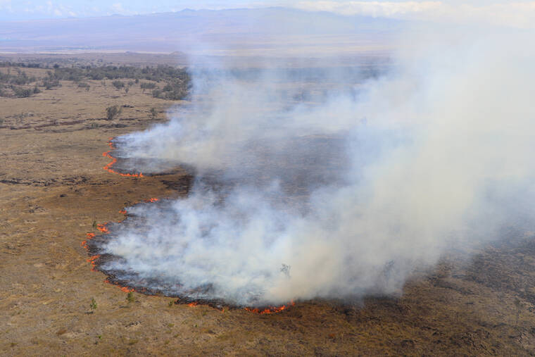
The fire, located in a remote area around the North Kona-South Kohala boundary line, was mapped at about 16,400 acres by the U.S. Army on Friday as county, state and federal assets battled the blaze for a third day. Containment was estimated at approximateluy 30%.
The U.S. Army said its firefighters were focused efforts Friday on the eastern portion of the fire to keep it from heading back toward the army’s Pohakuloa Training Area. In addition to ground crews, five Army helicopters were conducting water drops.
State and county personnel focused on the fire’s western edge, closer to Highway 190, as well as monitoring the fire, which has been blocked from advancing by the 1859 lava flow. Two Hawaii County helicopters assisted with water drops.
No homes or structures were threatened as of press-time. The fire was estimated to be just over 2 miles from Highway 190 and 3 miles from Puuanahulu.
The fire quickly grew from a flare-up Wednesday of an old blaze within the western portion of the U.S. Army’s Pohakuloa Training Area. According to officials, the fire had been smoldering in the area for several weeks, and high winds amid a red flag warning on Wednesday whipped up the flames.
The winds, estimated around 30 mph, fanned the fire to 700 acres by Wednesday night and to 10,000 acres by mid-day Thursday, after entering state lands outside the military installation. By Thursday evening, officials estimated it was upward of 15,000 acres.
“The last two days the fire was mostly burning in invasive fountain grass. It’s the first plant that comes in after fire disturbance. Unfortunately, the fire has moved into some dryland forest which has native ohia lehua and we are trying to keep flames away from this sensitive area,” said DLNR Division of Forestry and Wildlife Hawaii Island Branch Manager Steve Bergfeld, who is also one of three incident commanders on the fire.
Despite the fire, the division announced Friday that the Pu‘u Wa‘awa‘a Forest Reserve archery Makai hunt, and the youth and disabled hunt will be open this weekend. Staff will be at the hunter check station from 5:00 a.m. to 3:30 p.m. on Saturday and Sunday to sell tags and answer questions. Smoky conditions may impact hunters.
The cause of the initial fire remains under investigation, though the U.S. Army Garrison Hawaii said the blaze began in the western portion of the active military training area. The Army said the fire is several miles from the site where the Army in 2006 confirmed depleted uranium (DU) remains from spotting rounds used as part of the Davy Crockett program in the 1960s.
