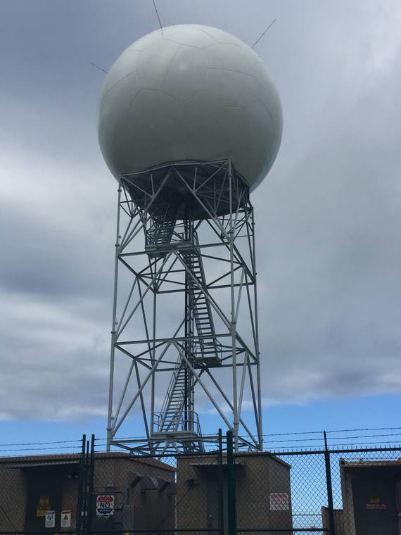
Driving Highway 11 from Volcano to Waiohinu on sunny, vog-free days, it’s hard to miss that bright white soccer ball on the slope of Mauna Loa above Pahala Town.
The curious white orb is the radome (housing) of the South Hawaii or Naalehu Weather Surveillance Doppler radar installation owned by the Federal Aviation Administration (FAA) and operated by the National Oceanic and Atmospheric Administration’s National Weather Service (NWS). It is one of two such facilities on Hawaii Island; the other sits atop Kohala to the north.
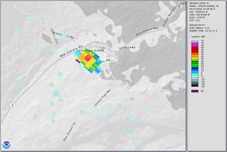
The radar’s job is to scan the atmosphere rapidly in all directions to locate and track weather clouds. Around the clock, the resulting information, maps and animations of the intensity of radar returns from the atmosphere extending more than 100 miles from the site. In the case of station PHWA, or the Naalehu radar, this extends from well southwest of South Point sweeping counterclockwise northeast off Cape Kumukahi and Hilo Bay. Data are displayed for all to see on a NOAA website.
Radar is a very useful tool because it penetrates clouds where the radar energy bounces off particles within the atmosphere and returns to the antenna. The strength of the return signals (known as reflectivity) are directly related to size and concentration of reflectors (usually rain droplets or ice particles). These data are used daily by weather forecasters, mariners, and anyone wanting helpful information on weather conditions and related hazards such as thunderstorms, hail, tornadoes, heavy rain, or flash flooding.
In 2018, this radar provided an additional service to Hawaii residents. Data from the Naalehu installation assisted the USGS Hawaiian Volcano Observatory (HVO), NWS, and other agencies to rapidly detect and characterize ash clouds that erupted from Kilauea Volcano’s Halema‘uma‘u Crater repeatedly in May and June. Although not strictly weather clouds, these plumes of rock, mineral, and glass particles behaved a lot like normal meteorological clouds: they rose through the atmosphere, mixing with or punching through the existing weather cloud deck, and then drifted downwind.
By examining the radar snapshot of the clouds within minutes of formation, NWS and HVO could estimate the maximum height of the cloud and then use a computer model to visualize where the cloud would move and how much ash might fall. This capability was especially useful at night when direct visual observations were not possible.
Most of the 2018 clouds were not very energetic as volcanic ash plumes go, rising less than 10,000 feet above the ground and producing only a trace of ashfall (about the thickness of a dime — less than 1 mm or 0.04 inch) as they drifted downwind, typically to the southwest with the trade winds. A few, however, contained more significant amounts of ash and left irritating amounts in the Ka’u Desert and communities downwind including Pahala, Naalehu, Ocean View, and possibly farther.
The tallest cloud was produced in the predawn hours of May 17, 2018. Based on radar, it reached as high as 30,000 feet above sea level, well above the elevations of the summits of Mauna Kea and Mauna Loa. Portions of the cloud moved northeast dropping ash on the Kilauea summit area including the Volcano Golf Course and Volcano Village.
Although a towering and impressive cloud, characteristics of the radar imagery and the resulting fallout pattern indicate that the upper portion of this cloud was ash-poor and consisted primarily of water or ice droplets. This is not surprising, as condensation of water high in an eruption cloud is a well-known occurrence in ash-producing eruptions worldwide.
In early 2020, the Naalehu radar was upgraded with a new pedestal to hold up the radar antenna and new internal electronics, communications, and other components. The work is part of a larger program of NOAA, the FAA, and the Department of Defense to refurbish all Doppler installations across the nation.
Here in Hawaii, we can rest assured that should Kilauea again produce ash clouds of any significance, the Naalehu radar stands guard, 24/7, to assist in rapid response. For more information about how a Doppler radar works, see this informative NWS website.
Visit https://volcanoes.usgs.gov/observatories/hvo/ for past Volcano Watch articles,for past Volcano Watch articles, Kilauea and Mauna Loa updates, volcano photos, maps, recent earthquake info, and more. Email questions to askHVO@usgs.gov.
Volcano Watch is a weekly article and activity update written by U.S. Geological Survey Hawaiian Volcano Observatory scientists and affiliates.