This week marks 150 years since the largest earthquake to strike Hawaii in the last two centuries. Estimated to have been at least magnitude-7.9, this earthquake struck near Pahala in the Ka’u District of the Island of Hawaii on April 2, 1868.
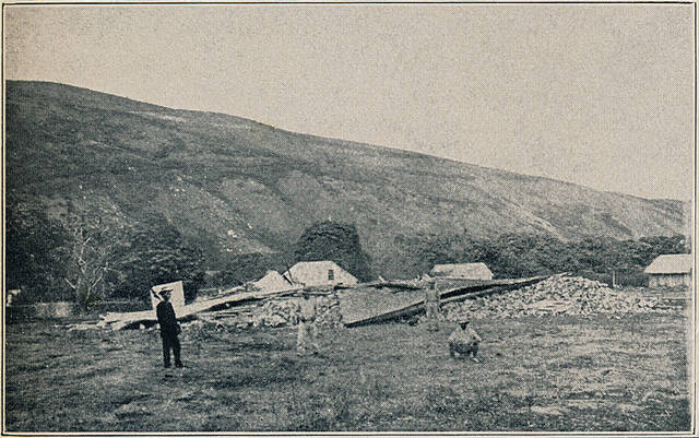
Known as the great Ka’u earthquake, the event had the same maximum intensity as the 1906 San Francisco earthquake, defined as “extreme shaking” on the Modified Mercalli Intensity Scale. It was felt as far away as Kauai and stopped clocks on Oahu. In Ka’u, where people were bounced like balls from shaking that went on for several minutes, the destruction was nearly total. Stone buildings and walls were destroyed as far away as Hilo.
The shaking caused landslides from Ka’u to Hawaii Island’s northern Hamakua Coast, and induced a small eruption on Kilauea Volcano’s Southwest Rift Zone. A mudslide in Wood Valley north of Pahala buried 31 Hawaiians. A tsunami, consisting of at least eight waves over several hours, was estimated to be more than 20 feet high in Ka’u. The waves caused damage from South Point (Kalae) to Cape Kumukahi (Kapoho), destroyed more than 100 structures, and took 47 lives.
If it happened today, the great Ka’u earthquake would be one of the world’s strongest earthquakes of this past year. Its size would also rival two of the most deadly events of the past decade: the magnitude-7.8 Nepal earthquake, which killed more than 8,000 people on April 25, 2015, and the magnitude-7.9 Sichuan (China) earthquake, which killed nearly 90,000 people on May 12, 2008. Because the Island of Hawaii was sparsely populated in 1868, the loss of life from the Ka’u earthquake was limited.
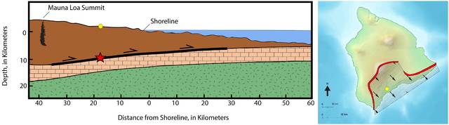
In Hawaii, the most destructive earthquakes occur along a gently sloping fault between the base of the volcanoes and the ancient ocean floor on which they are built. This fault, located at a depth of approximately 7 miles, is known geologically as a décollement, from the French word “décoller,” which means “to detach from.”
A large part of the Island of Hawaii moved during the 1868 event. Based on measurements of how much the earth moved during Hawaii’s magnitude-7.7 Kalapana earthquake in 1975, which also occurred on the décollement, the entire island south and east of Mauna Loa’s summit and rift zones moved seaward and subsided several yards during the great Ka’u earthquake of 1868.
The April 2 great Ka’u earthquake was part of a larger volcanic crisis that unfolded over 16 days. On March 27, an eruption quietly began in Mokuaweoweo, the caldera at the summit of Mauna Loa. Seismic activity increased through the day, and by the afternoon of March 28, a magnitude-7.0 earthquake occurred in Ka’u, which caused extensive damage from its own very strong to violent shaking.
During the following four days, nearly continuous ground shaking was reported in Ka’u and South Kona. Earthquakes continued at rates of 50 to 300 per day, including a magnitude-6.0 each day, leading up to April 2, when the great Ka’u earthquake, 15 times stronger than the magnitude-7.0 foreshock, occurred at 4 p.m. A severe aftershock occurred on April 4, and aftershocks of decreasing magnitudes continued for decades.
The great Ka’u earthquake unlocked Mauna Loa’s Southwest Rift Zone, and on April 7, 1868, an eruptive fissure opened low on the mountain, just above today’s Highway 11 and east of Hawaiian Ocean View Estates. This eruption and the lava flows it produced will be the focus of next week’s Volcano Watch.
Though we do not know how often events as large as the great Ka’u earthquake occur, we do know that, in Hawaii, active volcanoes drive the stresses that generate the largest earthquakes. Mauna Loa’s hazards, therefore, include eruptions, as well as large earthquakes along the décollement in Ka’u and South Kona—for example, the magnitude-6.9 earthquake that occurred near Captain Cook in 1951.
Because of this, Island of Hawaii residents are encouraged to be prepared for both volcanic eruptions and potentially damaging earthquakes.
Volcano Activity Updates
This past week, Kilauea Volcano’s summit lava lake level fluctuated with summit inflation and deflation, ranging about 23–75–115 feet below the vent rim. On the East Rift Zone, the 61g lava flow remained active with breakouts on the upper part of the flow field within 1.6 miles of Pu’u ‘O’o. There were no active lava flows on the pali, coastal plain, or entering the ocean. The 61g flows do not pose an immediate threat to nearby communities.
Mauna Loa is not erupting. Rates of deformation and seismicity have not changed significantly over the past week, but persist above long-term background levels. Only a few small-magnitude earthquakes occurred beneath the volcano, primarily at depths shallower than 8 miles. GPS and InSAR measurements continue to show slow deformation related to inflation of a magma reservoir beneath the summit and upper Southwest Rift Zone. No significant changes in volcanic gas release or fumarole temperature were measured.
One earthquake with three or more felt reports occurred in Hawaii this past week. On March 24, at 12:32 a.m., a magnitude-2.5 earthquake occurred two miles southwest of Volcano.
Visit www.volcanoes.usgs.gov/hvo for past Volcano Watch articles, Kilauea daily eruption updates, Mauna Loa weekly updates, volcano photos, maps, recent earthquake info and more. Call for summary updates at 967-8862 (Kilauea) or 967-8866 (Mauna Loa). Email questions to askHVO@usgs.gov.
Volcano Watch is a weekly article and activity update written by U.S. Geological Survey Hawaiian Volcano Observatory scientists and affiliates.


interesting…….
Thank you for this very informative report!