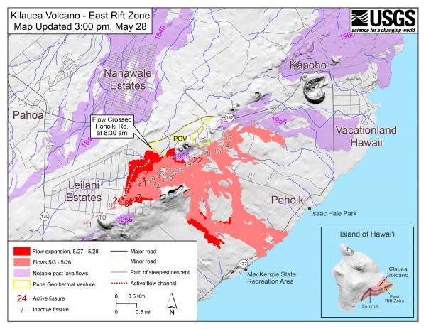
Highway 132 was shut down at 6:45 this morning from Lava Tree State Park to Four Corners due to a fast moving lava flow approaching the highway, the Hawaii County Civil Defense Agency reported.
Hawaiian Volcano Observatory reports the lava is flowing about 100 yards from the road. Everyone is advised to avoid the area.
Due to the lava activity the following policies are in effect:
- Only residents with placards are allowed to access Highway 137 beyond Four Corners.
- Residents close to any volcanic activity should remain alert and be prepared to voluntarily evacuate if necessary.
- If lava breaches Highway 132, the area along the highway; Vacationland and Kapoho Beach lots will experience an extended power outage.
Today’s community meeting at the Pahoa High School Cafeteria will begin at 5 p.m. The Department of Health will discuss vog and ash exposure in the Ka‘u District at Robert Herkes Gym and Emergency Shelter in Pahala at 5:30 p.m. on Wednesday.
Other policies also in effect:
- Beach Road is the only access into lower Puna.
- Access to Issac Hale Beach Park for recreation is closed.
- Residents close to the active eruption must remain alert to changes in the flow direction, and are advised to prepare for voluntary evacuation should their areas become threatened.
- You are advised to make necessary plans and monitor your radio or phone for Civil Defense alerts.
Hawaii Volcano Observatory also released status report. According to its report Tuesday morning, visual observations confirmed continued weak activity at Fissures 18, 19, and 20. Fissure 18 has produced channelized flows, which have advanced about one-third of the way (1.2 miles) toward the coast.
Pele’s hair and and other lightweight volcanic glass from high fountaining of Fissure 8 are being carried downwind and falling to the west of the fissure, according to the HVO report. On Monday night, there were reports of Pele’s hair falling in Pāhoa. Residents are urged to minimize exposure to these volcanic particles, which can cause skin and eye irritation similar to volcanic ash.
The most recent map of lava flows can be found here: https://volcanoes.usgs.gov/volcanoes/kilauea/multimedia_maps.html
Volcanic gas emissions remain high from the fissure eruptions. Trade winds are forecast to return in the coming days, meaning that vog may impact the southern and western sides of the island, according to the HVO report.
Magma continues to be supplied to the lower East Rift Zone. Earthquake locations have not moved farther downrift in the past few days and the number of located earthquakes remains low.
Additional ground cracking and outbreaks of lava in the area of the active fissures are possible. Residents downslope of the region of fissures should heed all Hawaii County Civil Defense messages and warnings.
USGS/HVO continues to monitor the lower East Rift Zone activity 24/7 in coordination with Hawaii County Civil Defense.
Kīlauea Volcano Summit
At 1:56 a.m.there was a small explosion from the vent within Halema‘uma‘u crater at Kilauea’s summit, which sent ash 15,000 feet above sea level. according to the HVO status report the ash cloud rose vertically above the summit and drifted only slightly to the northwest.
The explosion was reportedly felt by a number of residents in the Volcano area, and it resulted in the emplacement of some incandescent blocks on the east floor/wall of Halemaʻumaʻu crater.
Additional explosive events that could produce minor amounts of ash fall downwind are possible at any time. Volcanic gas emissions at the summit remain high.
For forecasts of where ash would fall under forecast wind conditions, please consult the Ash3D model output here: https://volcanoes.usgs.gov/observatories/hvo/activity_2018.html
Information on ash hazards and how to prepare for ashfall maybe found here: http://www.ivhhn.org/information#ash