One of the most interesting aspects of the current activity in Halema‘uma‘u is the occasional oozing of lava around the edges of the entire crater while the lava surface is rising. Has that phenomenon been reported before in any accounts of previous Kilauea activity?
Halema‘uma‘u filled and drained numerous times during the nineteenth and early twentieth centuries. One such cycle of rising lava level occurred between 1914 and 1918. Lava levels fluctuated but rose slowly until the 180 m (600 ft) deep pit was filled, finally spilling over the rim in February 1918.
Over the next 21 months, the pit overflowed more than dozen times, and lava erupted from a crack 200 m (650 ft) northeast of the pit. All Halema‘uma‘u surface activity abruptly ceased on November 28, 1919, when the lava surface dropped 180 m (600 ft) in a single morning, leaving a small triangular lava lake at its bottom.
Thomas Jaggar, founder of the Hawaiian Volcano Observatory, observed much of this activity and afterward noted that the pit walls were covered with “a veneer of glowing matter moulded against the walls of the pit, and … striated vertically.”
He concluded that a cylindrical shell of molten lava (ring dike) surrounding the more solid interior fill of the crater had remained liquid and that its “lubricating action…accounts for the extraordinary quietness and quickness” of draining on November 28th. He also noted that surface features of the new pit floor bore a strong resemblance to the features present before the collapse—the crater fill had dropped like a piston!
The pit began to refill almost immediately, first with an enlarging, rising lava lake, followed by bodily uplift of the floor. Molten lava emerged between the crater wall and the floor material, tilting the edges of the pit floor inward to create a basin in the center of the floor. Lava then flowed from a narrow circular lake between the pit walls and the uplifted floor edges to the central basin, forming a ring-shaped island. Jaggar considered this further evidence of a ring dike.
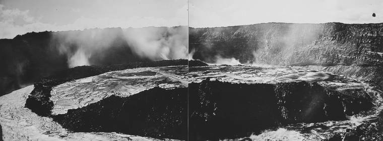
The eruption in Kilauea Iki in 1959 provided another opportunity to document lava lake behaviors. The eruption proceeded through 17 episodes of spectacular lava fountains in about 5 weeks, partially filling a pre-existing crater. The entire crust of the lava lake was frequently broken up by what is now called foundering.
“The process … began with molten lava lapping over the leading edge of the crust. Within seconds, or at most a minute, a major crack would form several feet back in the crust parallel to the edge…Then lava would rapidly well up in the major crack…tilting the detached block so that it slipped forward, or was dragged under, into the molten lava. The upwelling lava also lapped over the new leading edge of the old crust setting the stage for another cycle.”
During the eighth episode, scientists on the east edge of the lake noticed that the lake crust was slightly higher in the middle and it primarily foundered around the lower edges as overall lava level rose.
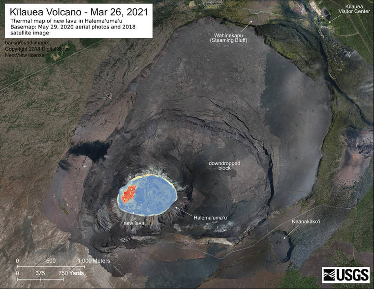
Which process is occurring at Halema‘uma‘u now?
The current lake surface shows no sign of being tilted radially inward by a ring dike around its edges as in 1919. Jaggar’s ring dike also produced lava emerging around the entire crater floor, but the current oozing activity usually appears briefly in limited areas cumulatively expanding the lake surface over time. Crust over a lava lake rising in a pit shaped like an inverted funnel may slowly open gaps between the crust edge and the pit walls. The crust around the edges are the newest and thinnest facilitating foundering.
Observations of previous activity at Kilauea’s lava lakes informs our understanding of ongoing processes in Halema‘uma‘u’s current lava lake. Continuous observation over time will give us a better sense of all aspects of lava lake mechanics at work today.
Please visit HVO’s website for past Volcano Watch articles, Kilauea and Mauna Loa updates, volcano photos, maps, recent earthquake info, and more. Email questions to askHVO@usgs.gov.
Volcano Watch is a weekly article and activity update written by U.S. Geological Survey Hawaiian Volcano Observatory scientists and affiliates.
^
Volcano Activity Updates
Kilauea Volcano is erupting. Its USGS Volcano Alert level is at WATCH (https://www.usgs.gov/natural-hazards/volcano-hazards/about-alert-levels). Kilauea updates are issued daily.
Lava activity is confined to Halema‘uma‘u with lava erupting from a vent on the northwest side of the crater and flowing into a growing lava lake. Laser rangefinder measurements this morning, April 1, indicate that the lava in the western (active) portion of the lake is 224 m (735 ft) deep, with the eastern portion of the lava lake solidified at the surface. The summit tiltmeters recorded neither inflationary nor deflationary tilt over the past day. Sulfur dioxide emission rates measured on March 31 were 700 t/d. Seismicity remains stable, with elevated tremor. For the most current information on the eruption, see https://www.usgs.gov/volcanoes/Kilauea/current-eruption.
Mauna Loa is not erupting and remains at Volcano Alert Level ADVISORY. This alert level does not mean that an eruption is imminent or that progression to an eruption from the current level of unrest is certain. Mauna Loa updates are issued weekly.
This past week, about 234 small-magnitude earthquakes were recorded beneath the upper-elevations of Mauna Loa; most of these occurred at depths of less than 8 kilometers (about 5 miles) and most were part of a swarm that occurred March 29-31 on the northwest flank. A tiltmeter near the summit showed a small contraction as the same time as the swarm and has since leveled off. Long-term Global Positioning System (GPS) measurements show slow summit inflation, consistent with magma supply to the volcano’s shallow storage system. Gas concentrations and fumarole temperatures at both the summit and at Sulphur Cone on the Southwest Rift Zone remain stable. Webcams show no changes to the landscape. For more information on current monitoring of Mauna Loa Volcano, see: https://www.usgs.gov/volcanoes/mauna-loa/monitoring.
There were two events with three or more felt reports in the Hawaiian Islands during the past week: a magnitude 3.3 earthquake 18 miles northwest of Volcano at 16 miles depth on March 30 at 6:09 a.m. HST and a magnitude 2.9 earthquake 12 miles south-southwest of Pa’auilo at 19 miles depth on March 28 at 7:05 a.m. HST.
HVO continues to closely monitor both Kilauea’s ongoing eruption and Mauna Loa for any signs of increased activity.