In a recent “Volcano Watch” article, we learned about a remote sensing technique known as InSAR. This method of using satellite radar signals to detect changes to the surface of the Earth has been very beneficial for the monitoring of active volcanoes, especially in remote locations where it is difficult to install ground-based geophysical sensors. One such place where InSAR recently proved instrumental in detecting deformation of a volcano previously considered inactive was in Southeast Alaska.
On April 11, 2022, Alaska Volcano Observatory (AVO) scientists observed seismic activity at Mount Edgecumbe on Kruzof Island near the town of Sitka, Alaska. Except for an elaborate April Fool’s Day prank in 1974, this volcano has remained quiet for around 4,000 years based on its geologic record.
Oral history of the local Tlingit recently handed down by Herman Kitka reports “a mountain blinking, spouting fire and smoke,” which perhaps describes a small fire fountaining eruption. This is possible as recently as 800-900 years ago; however, the timing of this oral history is uncertain.
Shallow, small earthquakes detected in April 2022 were broadly distributed to the northeast of the summit. This activity initiated a response by AVO scientists to try to understand the source of the earthquakes. Unfortunately, this volcano had no existing local ground-based geophysical instruments; the larger earthquakes described above were detected on distant seismographs of the regional seismic network used by the Alaska Earthquake Center to monitor tectonic activity. No seismographs or geodetic instrumentation existed close to the volcanic edifice that would be useful in detecting and interpreting subsurface activity of the volcano!
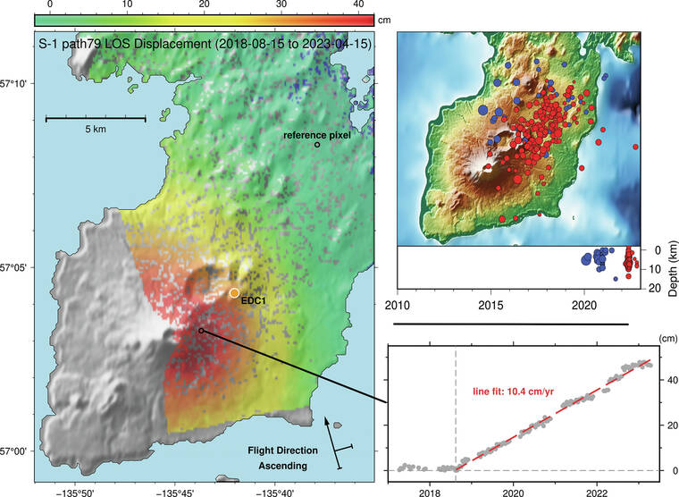
With no ground-based instruments installed near the volcano, satellite remote sensing techniques were used to investigate potential changes. An InSAR time series was utilized to search for surficial changes at Mount Edgecumbe. AVO scientists used sequential unwrapped interferograms to create a time series of change from several years of interferograms. Creating an InSAR time series allowed them to produce a cumulative displacement map, as shown in the image accompanying this article, where each colored pixel represents the total deformation at that location over the 7 years of this retrospective study. The results successfully identified deformation that started long before the recent earthquake swarm. Retrospective analysis of seismicity at the nearest seismograph in Sitka showed an increase in low-magnitude seismic activity in mid-2019.
Each colored pixel in these results represents the total movement of a patch of ground approximately 100 square feet (20-30 square meters) for this InSAR time series. The displacement data of a selected pixel, plotted on the lower right side of the image, has shown that steady inflation started sometime in August 2018, several years prior to the earthquake activity observed in April 2022. Steady inflation has continued since 2018. Results of this analysis prompted the Alaska Volcano Observatory to start the next phase of monitoring on Mount Edgecumbe. In the summer of 2022, a seismic and GNSS station (Global Navigation Satellite System, which includes GPS) station was installed near the volcano for active monitoring. The GNSS instrument gives a more precise 3-dimensional deformation estimate for the volcanic edifice, without the need to have to wait for a SAR satellite repeat visit (about 12 days). Together, GNSS and InSAR can give a very clear picture of magmatic processes, without having to be anywhere near the volcano for extended periods except a brief installation period!
An influx of magma into a volcanic edifice such as this does not indicate the potential of an eruption. This merely is the indication that there is some magmatic activity at depth. Scientists expect more changes in deformation, higher rates of seismicity, and detection of volcanic gases prior to any eruption at Mount Edgecumbe. This summer, AVO will install further instrumentation and conduct gas and geologic studies at Mount Edgecumbe, in addition to continued InSAR and seismic analyses, allowing scientists at the Alaska Volcano Observatory to better monitor this volcano for such changes. To learn more, see the recent publication detailing this study from AVO scientists.
Volcano Activity Updates
Kilauea is not erupting. Its USGS Volcano Alert level is ADVISORY.
Webcams show no signs of active lava in Halema’uma’u crater, at the summit of Kilauea in Hawaii Volcanoes National Park. Over the past week, summit tiltmeters showed inflation and seismicity remains elevated beneath Kilauea summit and Namakanipaio. The summit sulfur dioxide (SO2) emission rate was most recently measured on May 26, when it totaled 120 tonnes per day.
Mauna Loa is not erupting. Its USGS Volcano Alert Level is at NORMAL.
Webcams show no signs of activity on Mauna Loa. Seismicity remains low. Summit ground deformation rates show inflation above background levels, but this is not uncommon following eruptions. SO2 emission rates are at background levels.
There were two earthquakes with 3 or more felt reports in the Hawaiian Islands during the past week: a M2.6 earthquake 1 km (0 mi) WSW of Captain Cook at 8 km (5 mi) depth on May 29 at 9:34 p.m. HST and a M3.2 earthquake 4 km (2 mi) SSW of Pahala at 31 km (19 mi) depth on May 27 at 5:42 p.m. HST.
HVO continues to closely monitor Kilauea and Mauna Loa.
Please visit HVO’s website for past Volcano Watch articles, Kilauea and Mauna Loa updates, volcano photos, maps, recent earthquake information, and more. Email questions to askHVO@usgs.gov.
Volcano Watch is a weekly article and activity update written by U.S. Geological Survey Hawaiian Volcano Observatory scientists and affiliates.


