The 2018 collapse of southern Kaluapele (Kilauea caldera) left a pit whose lowest point was about 500 m (1,640 ft) above sea level (asl). Since 2020, that pit has filled to a little over 900 m (2,950 ft) asl and one might wonder how high the lava level could go. We can’t answer that question but we can get an idea by looking to Kilauea’s past.
The history of Kaluapele is a collection of periods of rising lava level within Halema’uma’u, often to the point of overflowing, followed by abrupt and rapid drops in the level. After some time, the sequence repeats, rising to a slightly higher level. The process resembles a “two steps forward, one step back” sequence, with slowly rising lava level peaks.
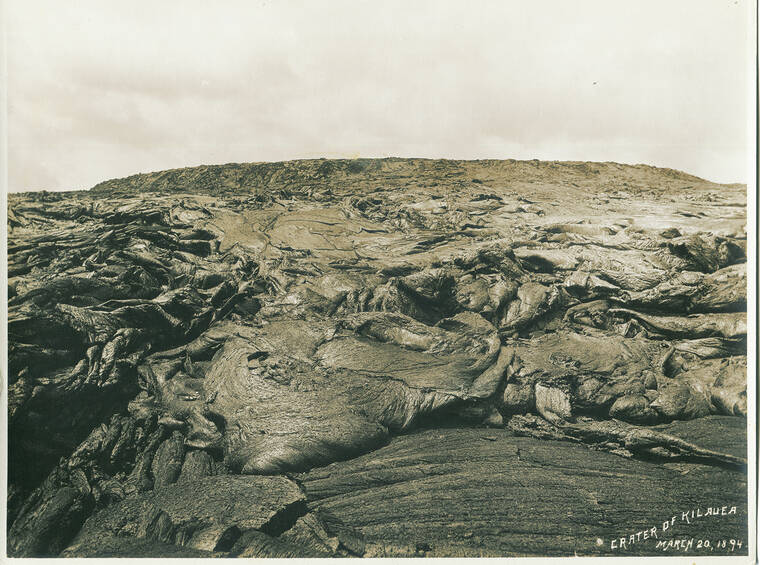
The highest level of lava in the past two centuries was reached in the first few months of 1894, during years of repeat surveys by the Hawaiian Government. Rapid drops of the lava level occurred on March 6, 1886, and again exactly five years later on March 6, 1891. The final rapid drop of the 19th century began on July 11, 1894.
Frank Dodge, a surveyor with the Hawaiian Government Survey, mapped Halema’uma’u in August 1892 and March 1894. The 1892 survey showed a lava lake 73 m (240 ft) below the rim of Halema’uma’u pit and 160 m (522 ft) below the Volcano House veranda on the northeast rim of the caldera (elevation 1231 m or 4,040 ft asl), then located about 150 m (490 ft) northwest of the current hotel. Elevations were measured multiple times with a surveyor’s theodolite to assure the highest accuracy possible. The lava level elevation was 1,072 m (3,518 ft) asl in August 1892.
The lava level continued to rise and, in the first months of 1894, visitors and residents found that lava frequently overflowed from Halema’uma’u onto the caldera floor. They also noted that the pit crater was filled, and the lava lake was “on top of a nearly circular cone” or hill.
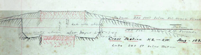
Dodge completed a follow-up map on March 20, 1894, confirming the filling of Halema’uma’u pit and the rising of the lava lake above the 1891 pit rims. The lava lake was about 6 hectares (15 acres) in area atop a low shield on the caldera floor. Instead of multiple measures of elevation below the Volcano House, he only made one.
The 1894 map was excellent; however, Dodge’s quick measurement of the lava lake elevation relative to the Volcano House may have been wrong. After completing the map in 1894, he stated that the lava level rose “447 ft in 19 months” since 1892; however, in 1904, he began to doubt that measurement and he added a note in the margin of this map saying that the 447 ft (136 m) change may be too high.
Dartmouth Professor emeritus C.H. Hitchcock suggested a compromise: assume that, in March 1894, Halema’uma’u was filled to the 1892 brim so the lava level rose by only 73 m (240 ft) between surveys. This ignored multiple reports and Dodge’s map of the lava lake being above the earlier rims.
Dodge responded that he could not accept Hitchcock’s suggested solution. “The height of the lava at the ‘supreme moment for Halemaumau’ will never be positively known … It was somewhere between the -75’ and -282’, referred to the Volcano House datum” (between 1145 and 1209 m asl).
In addition to the map, Dodge also drew August 1892 and March 1894 cross-sections of the Halema’uma’u pit at the same scale. If we ignore the questionable datum line on the 1894 cross-section and overlay on the 1892 cross-section by matching slopes outside the pit, we can graphically estimate the highest elevation. This simple exercise shows that the March 1894 lake must have been at least 30 m (100 ft) above the 1892 brim. This all-time peak elevation was a minimum of 55 m (180 ft) below the Volcano House veranda or 1,177 m (3,860 ft) asl.
For perspective, the 2008–2018 5 hectare (12 acre) lava lake rose to 1,034 m (3392 ft) asl just before its final drop during the 2018 summit collapse. The 2018 Halema’uma’u pit crater (150 hectares or 370 acres) is currently filled to about 920 m (3,020 ft) asl.
We have a long way to go to reach a new “supreme moment” for Halema’uma’u.
Volcano activity updates
Kilauea’s eruption is paused. Its USGS Volcano Alert level is WATCH.
The summit eruption at Kilauea volcano — which has been confined to Halema’uma’u crater—is paused, following a rapid decline in vent and lava lake activity in the afternoon of Monday, June 19. Simultaneously, seismometers detected a decline in eruptive tremor while tiltmeters began tracking gradual inflation that continues at this time. Volcanic gas emissions in the eruption area have dropped; a sulfur dioxide (SO2) emission rate of approximately 175 tonnes per day was measured on Wednesday, June 21, with this rate being a fraction of those measured before the eruptive pause.
Mauna Loa is not erupting. Its USGS Volcano Alert Level is at NORMAL.
Webcams show no signs of activity on Mauna Loa. Seismicity remains low. Summit ground deformation rates indicate slow inflation as magma replenishes the reservoir system following the recent eruption. SO2 emission rates are at background levels.
There was one earthquake with 3 or more felt reports in the Hawaiian Islands during the past week: a M2.5 earthquake near the Kilauea summit at 0 km (0 mi) depth on June 19 at 6:56 p.m. HST.
HVO continues to closely monitor Kilauea and Mauna Loa.
Please visit HVO’s website for past Volcano Watch articles, Kilauea and Mauna Loa updates, volcano photos, maps, recent earthquake information, and more. Email questions to askHVO@usgs.gov.
Volcano Watch is a weekly article and activity update written by U.S. Geological Survey Hawaiian Volcano Observatory scientists and affiliates.