Volcano Watch: Where is magma stored in Kilauea?
Over the past several months, periods of increased earthquake activity and ground deformation in the summit region of Kilauea volcano indicate that magma is accumulating beneath the surface. Where does magma reside, and how do we know?
First, let’s envision what a region of magma storage might look like. The top of an active magma chamber is hot with liquid rock. Deeper in the chamber, it transitions to slightly cooler, partially molten/partially solid, crystal-rich material, and eventually to relatively cold and brittle rock. The amount of magma in a reservoir fluctuates over time — there may be variations in the amount of magma coming into the reservoir from the hot spot or differences in the amount of magma being removed, due to eruptions or intrusions.
Fluctuations in the amount of magma in a reservoir cause changes in pressure that we can detect by earthquakes and ground deformation. Earthquakes don’t occur in liquids (such as magma), but their locations in cooler brittle rocks can approximately outline storage zones. Earthquakes also occur over a wider area of the volcano because of changing stresses from magma pressure and gravitational forces.
Along with earthquakes, the behavior of the ground surface above an area of magma storage can be an important indicator of conditions in the magma reservoir. When more or less magma is being stored, the ground surface above will move. Small changes in the ground’s surface are recorded by instruments on the ground, and also by satellite.
Earthquake locations and patterns of ground deformation give us clues as to where and how much magma is stored beneath the surface. The size, location and number of earthquakes, along with the area and amount of ground deformation, can be used to model the depth and volume of magma storage regions.
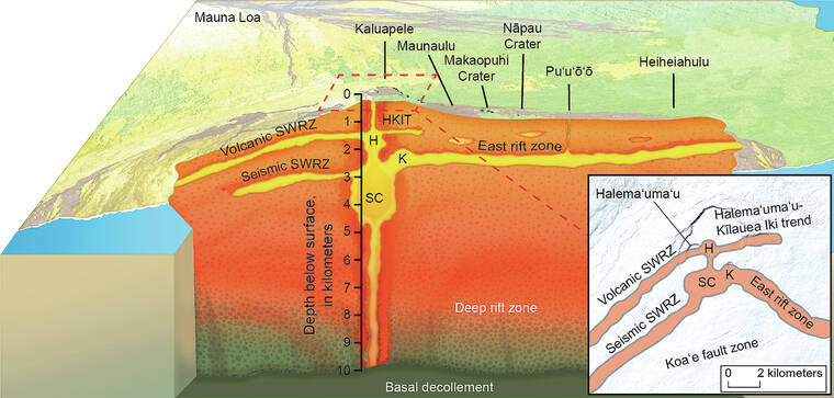
At Kilauea, there are several storage regions hypothesized from decades of monitoring data. Magma is stored in the Halema‘uma‘u reservoir, which lies about one mile (1–2 km) below the crater. Deflation-inflation (DI) events recorded by the tiltmeter near Uekahuna bluff, in Hawaii Volcanoes National Park, are thought to show changes in pressurization of this magma storage region, and this reservoir can drain during intrusions and eruptions. For example, the lower East Rift Zone eruption in 2018 removed so much magma from the Halema‘uma‘u reservoir that the summit caldera collapsed!
Another shallow reservoir, which is only intermittently active, is located near Keanakako‘i. There is also probably some magma stored in the Halema‘uma‘u-Kilauea Iki trend about a mile (1-2 km) of the surface, connecting the Halema‘uma‘u reservoir to Kilauea Iki. The September 2023 eruption occurred from this system.
Below the Halema‘uma‘u reservoir and slightly to the south is the larger main magma chamber for Kilauea, referred to as the south caldera reservoir. This body of magma is a couple of miles below the ground surface (3-5 km); it is fed by the hot spot and feeds the shallower Halema‘uma‘u reservoir, although the two reservoirs sometimes act independently, so the connection is not perfect. The south caldera reservoir also supplies magma to Kilauea’s main rift zones.
Magma can also be stored in an area referred to as the seismic Southwest Rift Zone, which lies about 2 miles (3 km) beneath the surface between Kilauea caldera and the Koa‘e Fault System. Episodes of magma accumulation in this region are frequent — for example, in 2006, 2015, 2021, and during October–November 2023; eruptions from this area, however, are rare.
Earthquake locations and patterns of ground deformation over the past several months suggest that several zones of magma accumulation at the summit have been recently active. In addition to the Halema‘uma‘u and south caldera reservoirs, magma appears to be leaking into the Keanakako‘i and seismic Southwest Rift Zone.
Why certain magma storage regions activate over others is not well understood, but recent observations continue to suggest that the summit of Kilauea is becoming increasingly pressurized over time. The USGS Hawaiian Volcano Observatory is closely monitoring this activity.
January is Volcano Awareness Month on the Island of Hawaii! Join us this coming week at one of the several events occurring.
Volcano Activity Updates
Kilauea is not erupting. Its USGS Volcano Alert level is ADVISORY.
Unrest in Kilauea’s summit region continues to wax and wane with fluctuating input of magma to the area. Earthquake activity in the summit region remained low over the past week, while tilt shows continuing inflation. Unrest may continue fluctuate and eruptive activity could occur in the near future with little or no warning. The most recent sulfur dioxide (SO2) emission rate for the summit — approximately 80 tonnes per day — was measured on Dec. 28. No unusual activity has been noted along the rift zones.
Mauna Loa is not erupting. Its USGS Volcano Alert Level is at NORMAL.
Webcams show no signs of activity on Mauna Loa. Summit seismicity has remained at low levels over the past month. Ground deformation indicates continuing slow inflation as magma replenishes the reservoir system following the 2022 eruption. SO2 emission rates are at background levels.
One earthquake was reported felt in the Hawaiian Islands during the past week: a M3.2 earthquake 14 km (8 mi) SE of Waikoloa at 33 km (21 mi) depth on Jan. 4 at 9:14 a.m. HST.
HVO continues to closely monitor Kilauea and Mauna Loa.
Please visit HVO’s website for past Volcano Watch articles, Kilauea and Mauna Loa updates, volcano photos, maps, recent earthquake information, and more. Email questions to askHVO@usgs.gov.
Volcano Watch is a weekly article and activity update written by U.S. Geological Survey Hawaiian Volcano Observatory scientists and affiliates.
