Volcano Watch: Hawaii represented at the Cities on Volcanoes conference in Antigua, Guatemala
In February, the volcanological community gathered for the 12th edition of Cities on Volcanoes (COV12), a conference of the International Association of Volcanology and Chemistry of the Earth’s Interior.
This conference series started in 1998, with the third conference held in Hilo in 2003; Cities on Volcanoes conferences are held every two to three years in a city that co-exists with and is influenced by volcanism.
This year COV12 was in Antigua, Guatemala, the colonial capital of Guatemala from 1543-1773, and a UNESCO World Heritage Site since 1979. Three volcanoes, Fuego, Agua, and Acatenango, are located near Antigua. Fuego is quite active: minor explosions happen multiple times a day, with the resulting ash plumes visible from Antigua (quite a sight over breakfast!). Tragically, on June 3, 2018, Fuego had its largest eruption in more than 40 years, with pyroclastic flows (fast moving flows of hot gas, volcanic ash, and rocks) killing hundreds of people, mostly within a single rural community on the southeast flank of the volcano.
About 650 people from around the world attended COV12, including volcano observatory staff, academics from a variety of disciplines, students, emergency managers and government officials, indigenous cultural practitioners, artists, and local residents. Seven State of Hawaii residents attended, hailing from the USGS Hawaiian Volcano Observatory, Hawai‘i County Civil Defense Agency, and the University of Hawai‘i (Hilo and Manoa).
Conferences such as COV12 allow participants to share experiences, ideas, observations, and research findings. Four of the five conference days either started or ended with three or four general talks followed by a panel discussion open to the public. Together, these sessions explored volcanology and risk reduction in Latin America and beyond, with special attention paid to the role and contributions of local and indigenous communities, and emerging, more inclusive and holistic research approaches. These were conducted in both English and Spanish, with simultaneous translation provided.
Most of the rest of the conference consisted of concurrent sessions, each grouped around a topic. Participants faced a tough choice for which of the many fascinating sessions to attend. Sessions at COV12 included short (5 minutes or less) and longer (12 minute) talks, panel discussions, facilitated participant discussions, and poster sessions that prompted engaging dialogues around specific studies, experiences, and initiatives.
The Hawaii contingent played an active role in the conference, including running and presenting in sessions such as Lessons from recent eruptions and other crises, Long-term engagement and interaction between civil authorities and volcano observatories, The Indigenous voice in volcanology, Multidisciplinary investigations to unravel the structure and dynamics of active volcanic systems, and Creating “volcano-ready” communities.
During the third day of the conference, participants could attend one of two field trips: visiting either Pacaya or Fuego volcano. Pacaya volcano is near the capital Guatemala City, and its eruption in 2010 resulted in volcanic ash covering the city and causing significant disruption (for example, the airport was closed for nearly five days). Those who chose the Pacaya field trip were treated to a long hike and beautiful vistas.
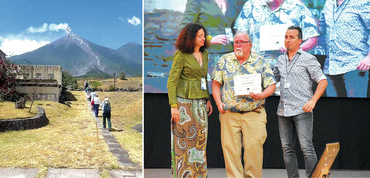
The Fuego field trip focused on that volcano’s deadly June 2018 eruption. Participants visited the La Reunión Golf Resort that was evacuated prior to pyroclastic density currents sweeping through, destroying and inundating much of the resort. This was followed by a visit to San Miguel Los Lotes, the village where hundreds of fatalities were caused by these pyroclastic density currents. Most buildings in this village are still buried under many feet and tons of deposits, with no night-time occupancy permitted. It was sobering and sad to walk down a cleared street near where so many had perished in and near their homes.
At the end of the conference, the late Dr. Jim Kauahikaua of HVO was awarded the first IAVCEI Honorary Award, along with the late Dr. Peter Hall from the Instituto Geofísico de la Escuela Politécnica Nacional (Ecuador’s volcano monitoring entity). This award was given in recognition of Jim’s contribution and services to volcano monitoring and risk reduction, which continues to serve as an example for the entire volcanology community. HVO Scientist-in-Charge Ken Hon gave a moving tribute in Jim’s honor.
Cities on Volcanoes will soon return to the USA for the first time since 2003, with the next edition to be held in Bend, Oregon, in 2026.
Volcano activity updates
Kilauea is not erupting. Its USGS Volcano Alert level is ADVISORY. Due to continued low rates of seismicity, HVO switched from daily to weekly Kilauea updates on March 5. Weekly Kilauea updates will be issued on Tuesdays until further notice. Low levels of disbursed seismicity at Kilauea’s summit and along the Koa‘e fault system southwest of the caldera continues; on average, earthquake counts remain below 10 per day. Tiltmeters near Sand Hill and Uekahuna bluff have continued to record very mild inflationary trends over the past week. No unusual activity has been noted along the rift zones.
Mauna Loa is not erupting. Its USGS Volcano Alert Level is at NORMAL.
Webcams show no signs of activity on Mauna Loa. Summit seismicity has remained at low levels over the past month. Ground deformation indicates continuing slow inflation as magma replenishes the reservoir system following the 2022 eruption. SO2 emission rates are at background levels.
One earthquake was reported felt in the Hawaiian Islands during the past week: a M2.1 earthquake 1 km (0 mi) WSW of Pahala at 31 km (19 mi) depth on March 5 at 8:54 a.m. HST. HVO continues to closely monitor Kilauea and Mauna Loa.
Please visit HVO’s website for past Volcano Watch articles, Kilauea and Mauna Loa updates, volcano photos, maps, recent earthquake information, and more. Email questions to askHVO@usgs.gov.
