Volcano Watch: What’s shaking at the summit of Kilauea?
This past week, earthquakes and inflation near Kilauea’s summit prompted temporary closures within Hawai‘i Volcanoes National Park. What is happening beneath the surface at Kilauea and what does it mean for potential future eruptive activity?
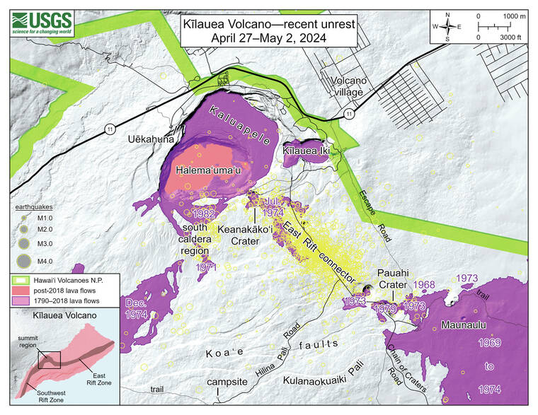
Earthquake activity in the upper East Rift Zone, directly southeast of Kaluapele (Kilauea’s summit caldera), increased around midnight of April 27. Since then, over 1,600 events have been recorded, most extending from Keanakako‘i crater southeast towards Pauahi Crater. Most earthquakes have been smaller than magnitude 2 and taking place at depths of 1.2–1.8 miles (2-3 km) beneath the ground surface.
Patterns of ground motion are consistent with inflation of the two main magma storage regions beneath Kilauea — Halema‘uma‘u and South Caldera. These magma bodies, which are long-term features of Kilauea’s summit plumbing system, began to re-inflate in tandem about a month after the short-lived September 2023 eruption. They then fed the intrusion into the Southwest Rift Zone in late January–early February 2024. Thousands of earthquakes accompanied that intrusion as magma moved underground to the southwest, where ground deformation was significant enough to cause ground cracks to appear on the surface along the Maunaiki Trail in Hawai‘i Volcanoes National Park.
Since the Southwest Rift Zone intrusion earlier this year, instruments have once again been showing signs of Kilauea’s shallow magma plumbing system refilling. The Sand Hill tiltmeter, which is sensitive to the deeper South Caldera magma reservoir of Kilauea, has shown steady inflationary tilt since early February. Data indicate that the South Caldera reservoir has regained the volume of magma that it lost during the recent intrusion, such that pressurization levels are now similar to pre-intrusion levels. The Uekahuna tiltmeter (UWE) is more sensitive to the Halema‘uma‘u reservoir, which has been the source for recent summit eruptions. UWE has shown slower inflation than SDH over the past few months, which implies that the South Caldera reservoir continues to be the main focus of magmatic recharge.
During the long-lived Pu‘u‘o‘o eruption, earthquake activity in the upper East Rift Zone of Kilauea sometimes occurred along with increased rates of tilt at Kilauea summit; this indicated that the summit magma reservoirs were becoming increasingly pressurized. When the 2008–2018 summit lava lake was active in Halema‘uma‘u, this increased pressurization was visible as a rise in the level of the lava lake, with its level acting like a barometer of the underlying Halema‘uma‘u magma chamber. The current increases in the number of earthquakes (particularly in the upper East Rift Zone) and rates of ground inflation are showing us that Kilauea’s magma storage system is becoming primed for its next event.
One potential outcome could be another significant intrusion — when magma moves into a new area within the volcano but fails to erupt on the surface — such as what occurred along the Southwest Rift Zone during late January/early February of this year. Another potential outcome could be another eruption, either inside or outside the caldera.
The eruptions within Kaluapele over the past several years have been preceded by about an hour of rapidly occurring earthquakes and greatly increased rates of ground deformation in the summit region as magma makes its way to the surface.
An eruption outside of the caldera, along one of the rift zones, would likewise be preceded by rapidly occurring earthquakes, along with greatly increased rates of ground deformation in the region of magma movement outside the summit region.
USGS Hawaiian Volcano Observatory (HVO) staff are closely monitoring and do not currently see signs of such magma movement in the dense network of monitoring instruments on Kilauea; currently activity is confined to the upper East Rift Zone and summit only. Though Kaluapele has been home to the last few years of eruptions, pit craters and lava flows in the upper East Rift Zone are evidence of a long history of magma moving along this rift zone pathway. Most recently, in November 1979, a brief one-day eruption occurred in and near Pauahi Crater; it was preceded by two months of 200–800 earthquakes occurring daily, along with inflation at the summit region.
Currently, there are no signs that an eruption is imminent; however, Kilauea monitoring data indicate that magma is once again accumulating and pressurizing in the long-lived magma bodies beneath Kilauea’s summit. How that pressure is released remains to be seen — HVO is closely monitoring multiple datasets for clues.
Volcano activity updates
Kilauea is not erupting. Its USGS Volcano Alert level is ADVISORY.
Rates of seismic activity significantly increased beneath the summit and upper East Rift Zone starting on April 27. Nearly 300 events, most magnitude-2 and smaller, have been detected per day between the southeast side of Kilauea caldera beneath Keanakako‘i crater and the intersection with Hilina Pali Road; depths remain concentrated between 2-3 km (1.2-1.9 miles) beneath the surface. Tiltmeters near Sand Hill and Uekahuna bluff continued to record inflationary trends. Kilauea’s summit region is pressurized, and changes could occur quickly moving forward. HVO has deployed a temporary webcam to Maunaulu to monitor the upper East Rift Zone: https://www.usgs.gov/observatories/hvo/kocam-live-image-upper-east-rift-zone-maunaulu. Hawai‘i Volcanoes National Park has closed several areas as a precaution: https://www.nps.gov/havo/learn/news/20240429-earthquake-closures.htm.
Mauna Loa is not erupting. Its USGS Volcano Alert Level is at NORMAL.
Webcams show no signs of activity on Mauna Loa. Summit seismicity has remained at low levels over the past month. Ground deformation indicates continuing slow inflation as magma replenishes the reservoir system following the 2022 eruption. SO2 emission rates are at background levels.
Six earthquakes were reported felt in the Hawaiian Islands during the past week: a M2.6 earthquake 5 km (3 mi) S of Volcano at 1 km (0 mi) depth on April 30 at 9:55 p.m. HST, a M2.6 earthquake 22 km (13 mi) S of Wai‘ohinu at 2 km (1 mi) depth on April 30 at 4:39 p.m. HST, a M3.0 earthquake 4 km (2 mi) S of Pahala at 31 km (19 mi) depth on April 30 at 3:50 p.m. HST, a M1.4 earthquake 6 km (3 mi) S of Volcano at 1 km (1 mi) depth on April 29 at 8:32 a.m. HST, a M3.3 earthquake 6 km (3 mi) S of Volcano at 1 km (0 mi) depth on April 28 at 11:14 p.m. HST, and a M2.0 earthquake 13 km (8 mi) SSW of Leilani Estates at 5 km (3 mi) depth on April 27 at 1:35 a.m. HST.
HVO continues to closely monitor Kilauea and Mauna Loa.
Please visit HVO’s website for past Volcano Watch articles, Kilauea and Mauna Loa updates, volcano photos, maps, recent earthquake information, and more. Email questions to askHVO@usgs.gov.
