Mauna Loa spews lava for first time since 1984; flows headed in ‘best possible direction’
Officials and residents are cautiously optimistic that Mauna Loa’s first eruption in nearly 40 years will be minimally disruptive.
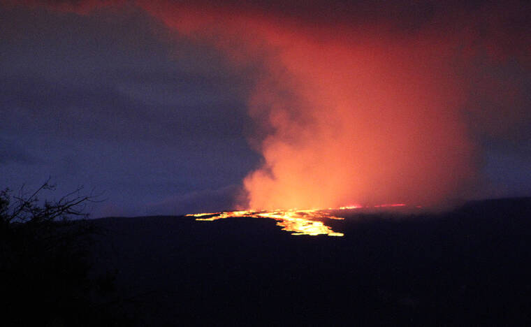
Mauna Loa, the largest active volcano in the world, began erupting late Sunday night, and the U.S. Geological Survey’s Hawaiian Volcano Observatory reported lava was inside Moku‘aweoweo, the volcano’s summit caldera, at about 11:30 p.m.
Resident Sean Sommers was one of many residents who ventured out in the wee hours to see the eruption that lit up the night sky. While pulled off Old Saddle Road around 5 a.m., he said Monday’s eruption was the second time he’s witnessed Mauna Loa send lava down its flanks. He added that his mother-in-law, who lives in Kawaihae, said she had never seen such a bright glow from the mountain in her lifetime.
“This is a lot bigger than 1984,” the long-time resident said while snapping photos of the orange glow with his cell phone in the cool night air.
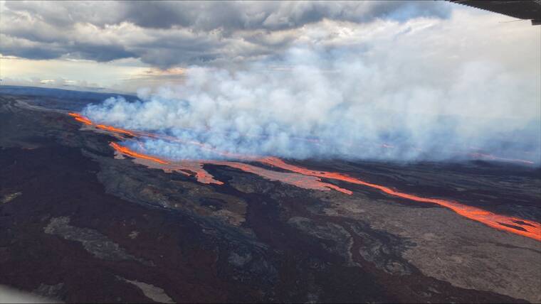
Over the next half-hour, the glow from the summit crater appeared to grow brighter. Around 5:30 a.m., photos taken by a West Hawaii Today editor posted at the Gilbert Kahele Recreation Area showed channels or “fingers” of lava forming on Mauna Loa’s northeastern flank. By 5:45 a.m., the channels of lava flowing downslope were clearly visible as the sky began to lighten in the morning hours.
Around 6:30 a.m. Monday, the U.S. Geological Survey’s Hawaiian Volacno Observatory confirmed that lava flows had broken out of three fissures that formed on the volcano’s northeastern flank.
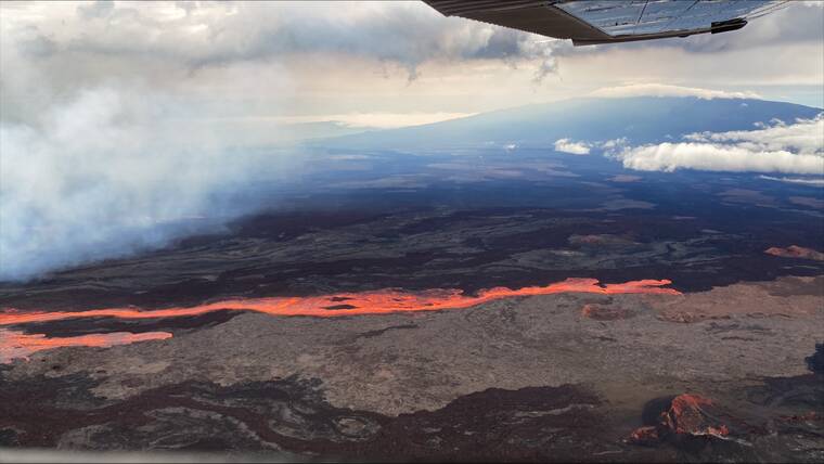
As of 1:30 p.m. Monday, there was no more active lava within the caldera, and only the lowest-altitude of the three fissures was producing lava. That fissure — dubbed Fissure 3 — produced a lava flow moving parallel with the Northeast Rift Zone. The flow was more than 10 miles away from the Daniel K. Inouye Highway. Flows from Fissures 1 and 2 stalled about 11 miles from the highway.
Mayor Mitch Roth said Monday that so far the eruption seems to be following the best scenario.
“We’ve been told that the lava is heading in the best possible direction, which is away from our communities,” Roth said in a statement, adding that the lava flow presented no imminent threat to any Big Island community.
During a press conference later Monday, HVO Scientist In Charge Ken Hon said the location of the lava suggests that it could eventually begin flowing in the general direction of Hilo, but added that it will take about a week before its direction will be apparent. He added that the eruption could mirror its previous eruption, in 1984, with the lava becoming more viscous and slow-moving over time.
Hon said the lava is heading toward the Big Island “saddle” — the large area between Mauna Loa and Maunakea — which he said is preferable because of the lack of human habitation and the relatively flat slopes that will further slow the flows. He added that the nearby Pohakuloa Training Area’s facilities are outside of the current predicted path for the flows, and that only the access road to the Mauna Loa Observatory is under potential threat.
A statement from the Pohakuloa Training Area stated that the U.S. Army is monitoring the situation, and there is no immediate threat to facilities or personnel.
“There are no troops training and we have suspended staff from going out to training areas as we monitor the situation,” said Public Affairs Officer Amy Stafford. “Business as usual but we are on alert and ready to send those with respiratory issues home, if needed.”
She asked that curious onlookers who decide to view the flow from Daniel K. Inouye Highway be cautious.
“We just ask everyone to use extra caution because some are pulling back on the road without paying attention to oncoming traffic,” Stafford said.
Hon said Mauna Loa eruptions are historically most energetic within the initial week or two, and “calm down” afterward. While he said there is no guarantee that this eruption will be the same, he added that he is not expecting it to last as long as the 2018 Kilauea eruption, which went on for four months and destroyed nearly 700 homes.
“As far as we know in any historic precedents, there has never been an eruption of Mauna Loa that activated both rift zones at the same time,” Hon said. “So, we presume at this point that all of the future activity is going to be on the Northeast Rift Zone of Mauna Loa and not on the Southwest Rift Zone, so the residents in that area do not have to worry about lava flows.”
Those communities include places like Ocean View and Pahala, where the steep southwestern slopes of Mauna Loa would accelerate any lava flows significantly. At an Ocean View community meeting in October, HVO scientists reported that lava flows in the Southwestern Rift Zone can reach the ocean within three hours.
Before it was clear where the lava was headed on Monday, residents of the island’s southern communities worked to prepare for disaster.
Cristen Navarro, an employee at a Naalehu gas station, said cars lined up and down the street as people bought gas and water in case of an eventual evacuation.
“It got to the point where we’ve had to limit it to like one thing of toilet paper per person,” Navarro said. “We opened at 4:30 a.m., and it’s been really busy all day.”
Other Pahala residents took a relaxed view of the situation. Resident Fidel Agustin said he had no reason to be afraid — “If you take care of the aina, then it will take care of you,” he said — while Julia Neal, owner of Pahala Plantation Cottages, said she was glad the weeks of waiting for the eruption to start are finally over.
“It’s kind of a relief that it’s happening and we’re not waiting for it to happen,” Neal said.
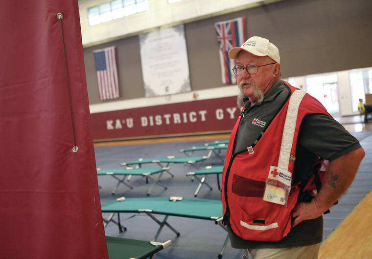
While the county made no evacuation orders, it did open a pair of emergency shelters in Pahala and Kailua-Kona in response to reports of people evacuating on their own.
Red Cross Shelter Manager Warren White said the Pahala shelter has cots for about 200 people, but added that it could be relocated to a different location depending on where the lava goes.
“It’s up to (Hawaii County) Civil Defense,” White said. “If it doesn’t get used, then at least it was a good drill for us.”
Several parties, including at least one family with children, had registered at the Red Cross shelter established at Kekuaokalani Gymnasium, Red Cross staff said.
Civil Defense Administrator Talmadge Magno said the county would make a decision about whether to keep the shelters open based on a review of their populations Monday afternoon.
On Monday evening, the state Department of Education announced that all public school campuses on Hawaii Island were slated to remain open.
“As with all emergencies, the health and safety of our students and staff is our top priority. Our goal is to be able to keep schools open as long as we can do so safely, and avoid having to abruptly close school during the school day. We will be reviewing conditions on a daily basis, looking at a variety of factors such as air quality, transportation, and the direction of the lava flow. In the event that school operations are impacted, families will be notified and updated through official school channels,” a statement attributed to the island’s three complex area superintendents read. “All Hawaii Island schools are updating their contingency plans to account for this type of emergency, should a school need to transition to a different mode of instruction for an extended period of time. Transition plans will be communicated to school communities as needed.”
In the event that school operations are forecast to be impacted, the department said families will be notified immediately. In the meantime, families are advised to make sure their child’s school has the most accessible contact information on file.
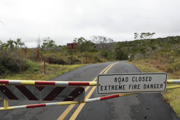
Meanwhile, Hawaii Volcanoes National Park, where Mauna Loa summit is located, made some closures following the eruption Monday.
Mauna Loa Road has been closed to vehicles, while the summit, cabins and other high-elevation areas have been closed since early October.
Park spokeswoman Jessica Ferracane said the Federal Aviation Administration has temporarily restricted flights within a five-nautical-mile radius around the Mauna Loa summit.
“Hawaii Volcanoes National Park is keeping close watch on Mauna Loa in tandem with our colleagues at USGS and Hawaii County Civil Defense,” said Hawaii Volcanoes National Park Superintendent Rhonda Loh. “The park is currently open, but visitors should be prepared and stay informed.”
But while the lava itself isn’t posing an immediate threat to people, the state Department of Health warned residents that air quality conditions could worsen as a result and advised people to avoid heavy breathing or opening doors and windows if volcanic fumes or ash levels increase. Hon said models predict that sulfur dioxide and other gases could be blown northward and toward Maui.
The volcano, which stands about 13,680 feet above sea level on the island of Hawaii, last erupted in 1984, the observatory said. That eruption sent lava within 4 miles of the “city limits” of Hilo. Including Monday’s eruption, Mauna Loa has now erupted 34 times since 1843.
All of Mauna Loa’s eruptions have commenced at the summit, with about 48% staying within the caldera. Outside the caldera, an estimated 24% occurred along the Northeast Rift Zone and 21% occurred along the Southwest Rift Zone, according to the U.S. Geological Survey and West Hawaii Today archives.
Six percent — or three eruptions — occurred from radial vents on the volcano’s north, northwestern and western flanks. In 1877, an eruption started at the summit phase, migrated to a radial vent near Kealakekua Bay resulting in reports of “floating rocks that were too hot to carry,” discolored water and sulfur gases. In 1859, an eruption on the northwest flank sent lava all the way to Kiholo Bay in just eight days.
In 1950, Mauna Loa erupted from its Southwest Rift Zone at nearly 10,000 feet, sending red hot rock down the volcano’s steep flanks, crossing Highway 11 in three places and reaching the South Kona shoreline within about three hours.
Mauna Loa’s new eruption brings the number of volcanoes actively emitting lava on the Big Island to two; Kilauea Volcano has been erupting since Sept. 29, 2021, with lava confined to the summit lava lake.
The AP contributed to this report.
Email Michael Brestovansky at mbrestovansky@hawaiitribune-herald.com. Email Chelsea Jensen at cjensen@westhawaiitoday.com.
