Volcano Watch: Learning from the 1984 eruption of Mauna Loa
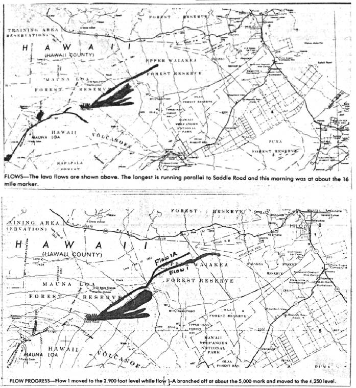
Inflation and earthquake activity ramped up prior to Mauna Loa’s 1984 eruption, so much so that in June of 1983, the USGS Hawaiian Volcano Observatory (HVO) indicated that an eruption could occur during the following year, though the exact timing was unknown.
Remembering Mauna Loa’s 1975 eruption
Mauna Loa erupted 46 years ago this week, on July 5 and 6, 1975, in a 20-hour event with vents confined to the summit region (the area above 12,000 feet) and lava flows descending to just below 10,400 feet. This was the first eruption in 25 years, at the time the longest quiet stretch since 1843 (we are currently in the longest stretch at 37 years and counting).
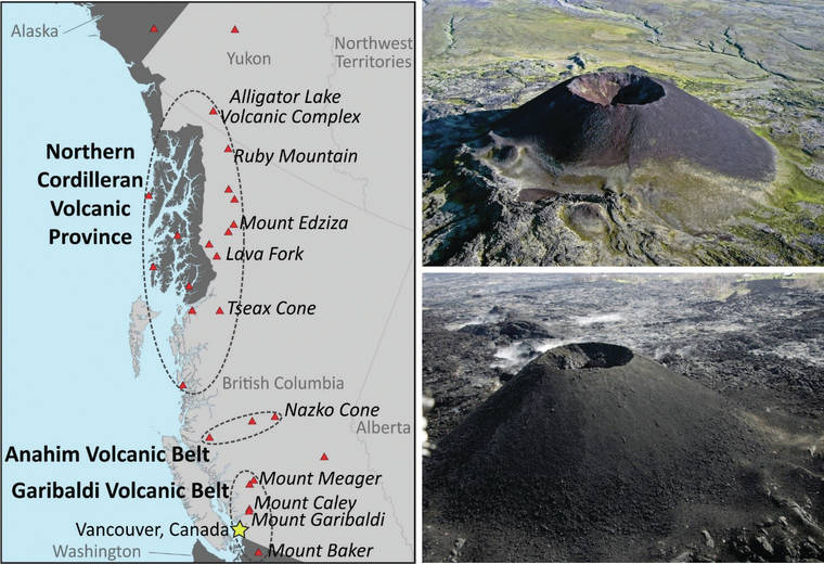
Volcano Watch — Volcanoes in Canada, eh?
Happy Canada Day/Bonne Fête du Canada! While some past “Volcano Watch” articles have had a July 4 theme for the USA, this year we’re taking the opportunity to ensure readers know that our neighbors to the north have volcanoes, too—including potentially active ones.
Volcano Watch: Seismic halfalogues — Earthquakes are only part of the conversation
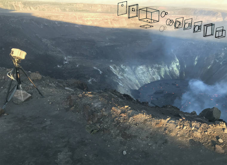
Volcano Watch: New instrument measures lava lake with laser
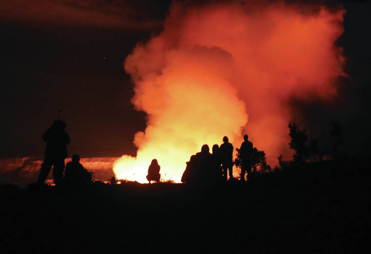
Eyewitnesses drawn to the crater rim were excited, reverent, and watchful. The eruption onset was observed near and far via technology. The USGS Hawaiian Volcano Observatory (HVO) was onsite and online, transmitting scientific information as the eruption response mounted.

Volcano Watch: Another way HVO tracks changes on Hawaiian volcanoes
Geodetic surveys measure the change in shape of our volcanoes due to changes in magma supply and storage. The USGS Hawaiian Volcano Observatory has a long history of using many different types of instruments and technologies over the decades to detect these changes.
Volcano Watch: What defines an eruption pause?
Kilauea’s recent volcano alert-level change, from “Watch” to “Advisory,” has attracted some attention.
Earthquake at Lo‘ihi rattles Big Island
A magnitude-4.0 earthquake that struck Wednesday evening below the Lo‘ihi seamount appears to have had no impact on Kilauea or Mauna Loa volcanoes, the USGS said.

Mauna Loa eruption evacuation plan in works
The Hawaii Emergency Management Agency will develop an evacuation plan for Hawaii County in the event of an eruption of Mauna Loa.
Volcano Watch: Pau or paused? What’s the difference?
Kilauea Volcano stops erupting after months of lava
HONOLULU — Kilauea Volcano has stopped erupting.
Earthquake hits beneath south flank of Kilauea Volcano
HONOLULU — A magnitude-4.2 earthquake struck Sunday beneath the south flank of Kilauea Volcano, the U.S. Geological Survey’s Hawaiian Volcano Observatory reported.
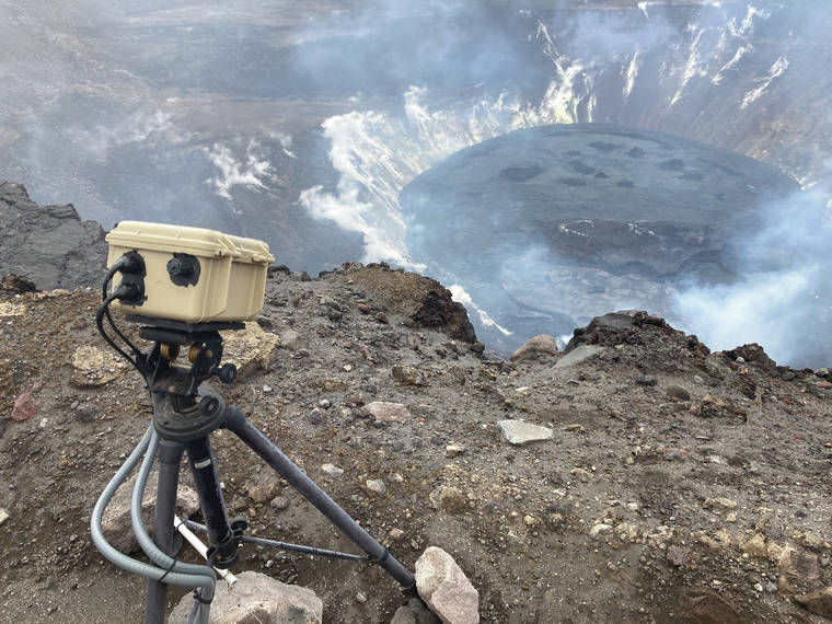
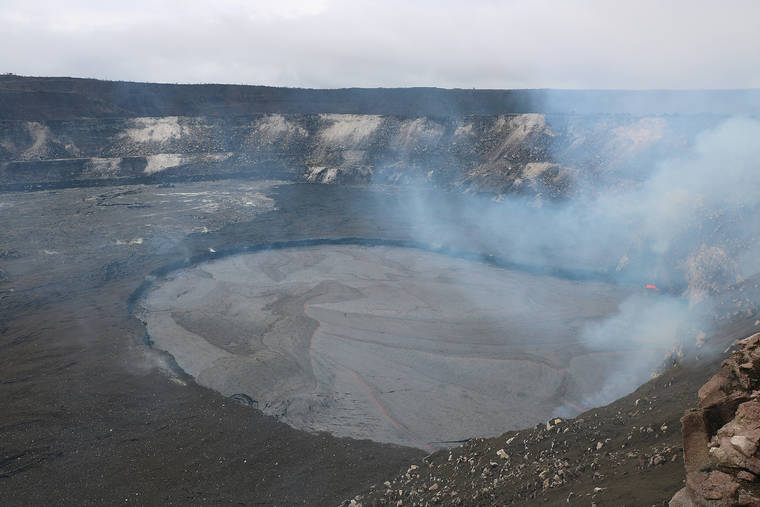
Volcano Watch: How are lava levels and volumes measured at the Kilauea summit lava lake?
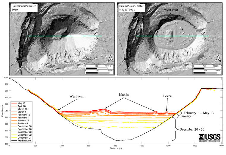
Kilauea’s summit lava lake in Halemaʻumaʻu is approaching its five-month anniversary on Thursday, May 20, while the water lake that occupied the crater for the previous seventeen months seems like a distant memory.
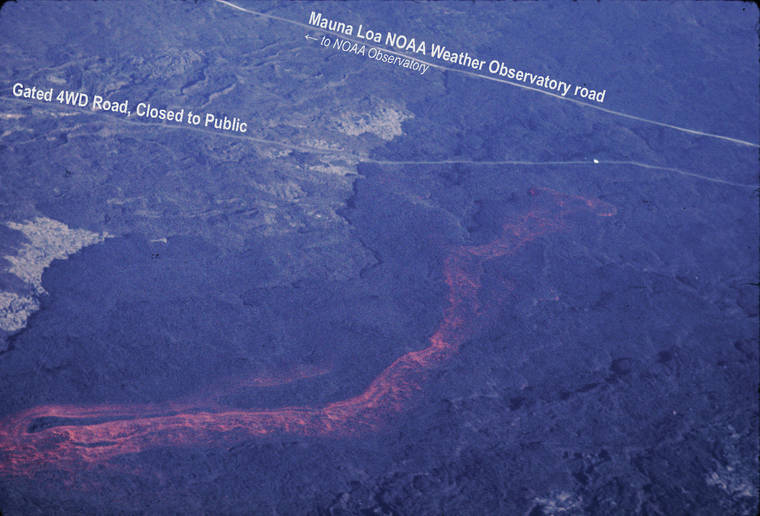
Volcano Watch: Tiny changes at Mauna Loa’s summit hold big clues
Volcano Watch: The rise and fall of lava lakes

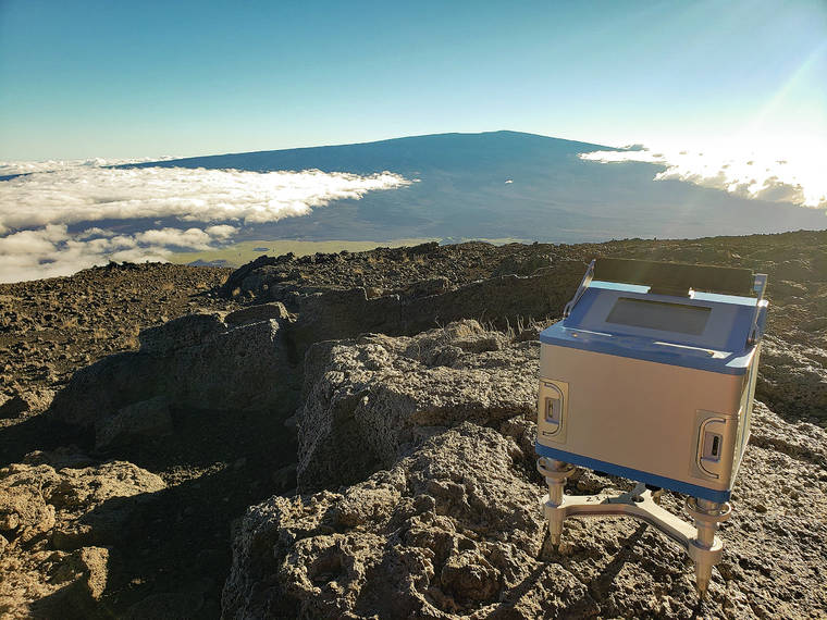
Volcano Watch: How measuring gravity on Maunakea helps us monitor Mauna Loa
It’s 5 a.m. and a somewhat sleepy scientist is getting ready to leave his home in Honomu and head to the USGS Hawaiian Volcano Observatory (HVO) office on Kamehameha Avenue in Hilo. Yawning — and not quite fully caffeinated — he says goodbye to the dog following him around the kitchen who’s wondering why they’re up so early.
Volcano Watch: Young activity in the Southwest Rift Zone
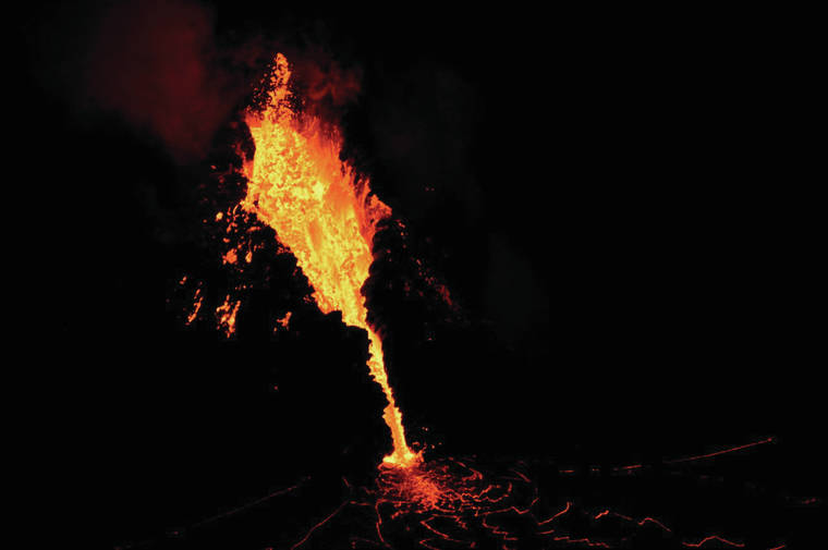
Kilauea’s East Rift Zone has been particularly newsworthy over the past 40 years with Pu‘u ‘O‘o erupting nearly continuously from 1983 to 2018 followed by the 2018 eruption that started in Leilani Estates. The summit of Kilauea also saw eruptions in April and September of 1982 and the 2008-18 lava lake which drained and was followed by impressive collapses from May to September 2018. The newly enlarged Halema‘uma‘u Crater is currently filling with lava from an eruption that began in December of 2020. The frequent summit and East Rift Zone eruptions often seem to overshadow Kilauea’s Southwest Rift Zone, which extends southwest from Halema‘uma‘u to the coast about 3 miles southeast of Pahala.
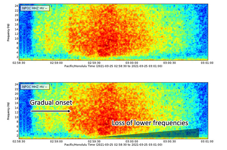
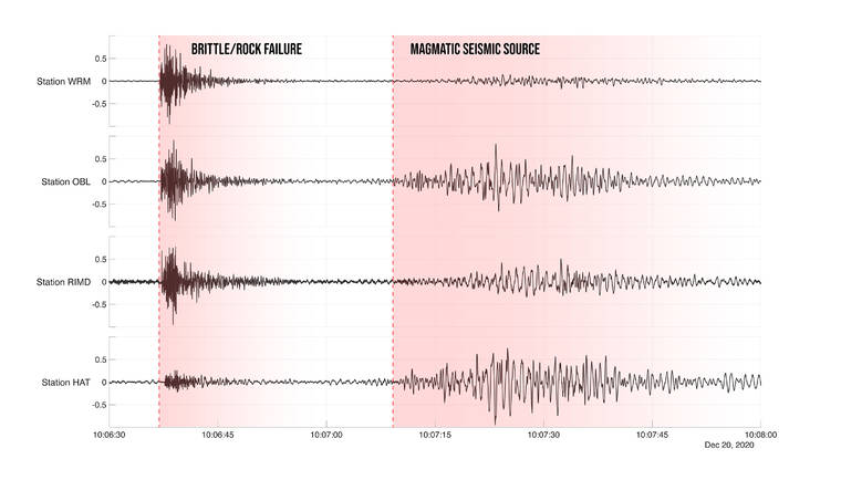
Volcano Watch: What’s that (seismic) noise?
The U.S. Geological Survey’s Hawaiian Volcano Observatory uses dozens of seismometers to locate individual earthquakes and identify signals that are related to faulting and magma movement within our volcanoes.
Volcano Watch: Aerial photographs and volcanic ash — looking back to move forward
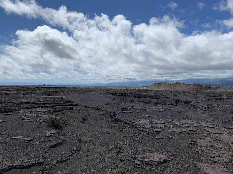
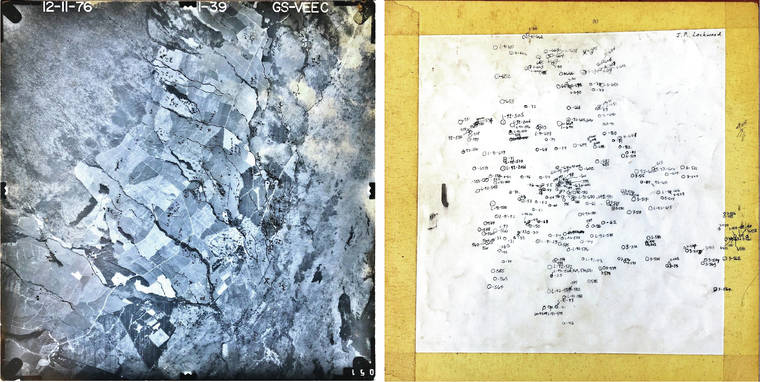
A new project at the USGS Hawaiian Volcano Observatory (HVO) is once again making use of old aerial photographs and field notes that were used to make geologic and hazard maps. Buried within hundreds of old mapping photos and field notes are the locations and thicknesses of several ash deposits on the flanks of Mauna Loa that have never been fully quantified.
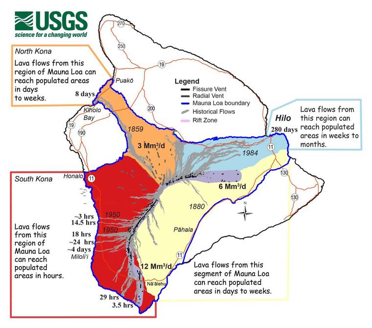
Volcano Watch: Failing to prepare, or preparing to fail
Mauna Loa has been in the news lately, as the volcano continues to awaken from its slumber. While an eruption of Mauna Loa is not imminent, now is the time to revisit personal eruption plans. Similar to preparing for hurricane season, having an eruption plan in advance helps during an emergency.
