New County Council districts proposed by the Redistricting Commission are now ready for prime time, and the commission has set hearings next week to see what the public thinks of its work.
“It’s 100% important and crucial that the public come out and speak out on the proposed map,” said Redistricting Commission Chairman Bronsten-Glenn Kossow. “People have real issues in their districts and so next year when the election rolls around, they’ll have council members that represent them. We want everyone to come out and speak and give us guidance as a commission.”
Commissioners on Thursday batted back last-minute changes proposed by one member, saying after hours upon hours of tweaking the maps over many months to make them as even as possible, it was no longer the time for second thoughts.
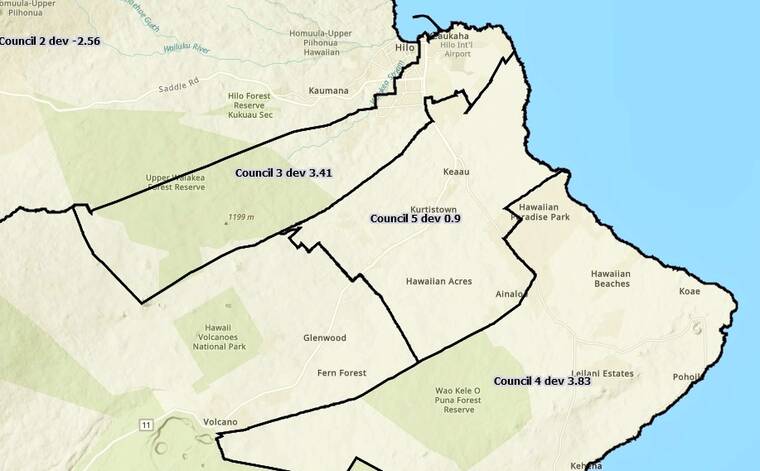
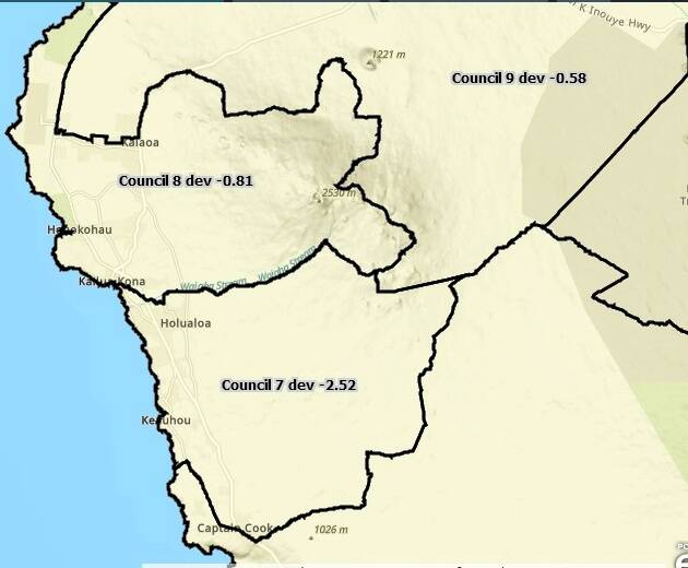
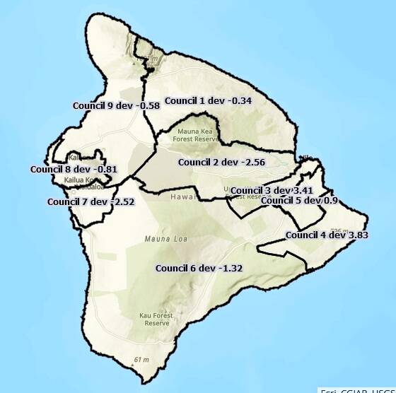
The commission is working to make each of the nine council districts as close to the ideal 22,232 people per district as possible. Districts shouldn’t deviate more than 10% above or below that ideal, nor should the difference between the most populated and least populated.
Currently, the difference between most and least populated stands at 19.38%. Ideal districts follow permanent and easily recognized features like rivers and roads, are compact and contiguous and don’t split neighborhoods of similar interest.
The public can compare the current map and draft map by visiting https://arcg.is/1CfTe10 . The draft map is the second tab from the left as marked, following the current council district map. The map also reflects population figures for each district should the proposal be put in place. The website features GIS and users can zoom into areas of interest using the plus and minus keys.
The county has posted 3-foot-by-4-foot copies of the maps at all 12 state libraries on the island and will also have them available at the public hearings.
The West Hawaii hearing is set for 6:30-8:30 p.m. Tuesday at Kona Council Chambers-West Hawaii Civic Center. The East Hawaii hearing is set for 6:30-8:30 p.m. Thursday at Hilo Council Chambers- County Building.
The public can attend the meetings in person or watch on the Redistricting Commission’s Youtube channel: https://www.youtube.com/channel/UCYzBy9MDf-zQXm2yqq2sklag.
The large-format maps will also be available at the public hearings, where the public can attend in person or by videoconference. Written testimony is welcomed on a continuous basis to redistrictingcommission@hawaiicounty.gov or 25 Aupuni St #1402, Hilo, HI 96720.